There’s something about standing at the base of a waterfall that makes you feel small in the best possible way. The mist on your face, the roar in your ears, and the sunlight catching every droplet — it’s like stepping into a real-life fairytale. That’s exactly how I felt the first time I hiked to Watson Falls in Oregon. What started as a weekend adventure turned into a full-blown obsession with chasing waterfalls all over the state.
Whether you’re planning your first trip to Oregon or you’ve lived here your whole life and want to explore deeper, this post is for you. I’ve handpicked the most breathtaking waterfall hikes in Oregon — not just the famous ones, but also the quiet trails where you’ll have the view (and the magic) all to yourself.
These aren’t just hikes. They’re moments you’ll remember — the kind where you lose track of time, breathe a little deeper, and leave with shoes soaked but heart full. From quick trails you can do in an hour to day hikes worth every step, here are the Oregon waterfall hikes that’ll have you lacing up your boots and grabbing your camera.
20 Hikes in Oregon with Waterfalls at a Glance
| Waterfall | Region | Difficulty | Trail Distance | Height | Why Go? |
| Multnomah Falls | Columbia Gorge | Easy | 0–2.4 miles | 620 ft | Oregon’s iconic waterfall |
| Bridal Veil Falls | Columbia Gorge | Easy | 0.6 miles | 120 ft | Short + scenic |
| Munson Creek Falls | Oregon Coast | Easy | 0.5 miles | 319 ft | Tallest waterfall in the Coast Range |
| White River Falls | Eastern Gorge | Easy–Moderate | 0.7–1.4 miles | 90 ft | Desert canyon + old power plant |
| Paulina Creek Falls | Central Oregon | Easy–Moderate | 0.5–1.8 miles | 80 ft | Twin volcanic plumes |
| Latourell Falls | Columbia Gorge | Easy–Moderate | 2 miles | 249 ft | Basalt cliffs + fewer crowds |
| Tumalo Falls | Bend | Easy–Moderate | 0.5–8 miles | 97 ft | Multiple falls upriver |
| Tamanawas Falls | Mt. Hood | Moderate | ~4 miles | 100 ft | Gorgeous basalt amphitheater |
| Proxy Falls | McKenzie Pass | Easy | 1.6 miles | 226 ft | Mossy, magical, highly photogenic |
| Sweet Creek Falls | Coast Range | Easy–Moderate | 2–5 miles | Series | Bridges + mini-falls wonderland |
| Shellburg Falls | Near Salem | Easy–Moderate | 1–5 miles | 100 ft | Can walk behind it |
| Sahalie & Koosah Falls | McKenzie River | Easy–Moderate | 2.6 miles | 70–100 ft | Roaring blue river water |
| Toketee Falls | North Umpqua | Easy–Moderate | 0.8 miles | 113 ft | Perfect amphitheater walls |
| Watson Falls | North Umpqua | Moderate | 0.8 miles | 272 ft | One of Oregon’s tallest |
| South Falls | Silver Falls SP | Easy–Moderate | 1–7 miles | 177 ft | Walk behind the curtain |
| Abiqua Falls | Scotts Mills | Hard | 0.7–1 miles | 92 ft | Ropes, roots, adventure |
| Downing Creek Falls | Santiam Pass | Hard | 1 mile | — | True hidden gem |
| Gorton Creek Falls | Columbia Gorge | Hard | 1.5 miles | 100 ft | Boulder hopping + moss canyon |
| Linton Falls | Three Sisters | Very Hard | 4.5+ miles | 615 ft total | Remote, wild, rugged |
| Twister Falls | Eagle Creek | Hard | 12 miles | 140 ft | Narrow ledges + huge payoff |
🚗 Easy Roadside Waterfalls
Perfect for the “I just want the waterfall without the workout” crowd.
Multnomah Falls
- Region: Columbia River Gorge
Trail Stats: 2.4 miles round-trip to the overlook, ~800 feet gain, paved but steep; or just a few minutes to the lower viewpoint.
Height: 620 feet - Difficulty: Easy to viewpoint, moderate to the top (11 switchbacks).
- Access & Parking: I-84 exit 31; huge but very busy lot. Summer timed-entry permits required for part of the day via Recreation.gov.
- Best Season: Year-round; spring for peak flow, fall for color, winter for occasional ice.
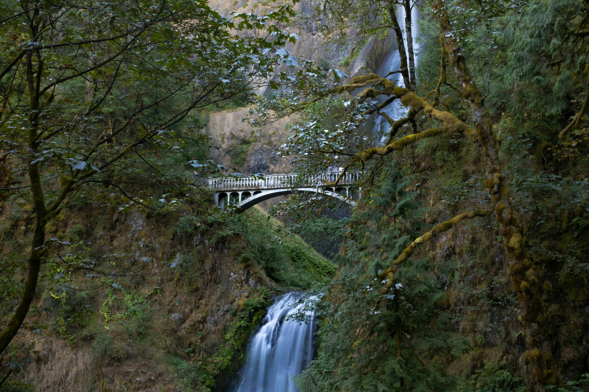
Ah yes, the Beyoncé of Oregon waterfalls. Yes, it’s touristy. Yes, it’s the most photographed waterfall in Oregon. And yes — Multnomah Falls is still worth it.
Click here for my post about road tripping the Columbia River Gorge.
I’ve been here more times than I can count, and it never stops feeling grand. The first time I saw it, I stood at the base, neck craned, jaw dropped, mist on my face — and just stared. At 620 feet, split into two tiers with that iconic footbridge suspended between them, Multnomah looks like something out of a painting. Both dramatic and timeless, it deserves its reputation.
The quick walk to Benson Bridge is enough to feel the power and take in the view, but if you’ve got the time and legs, climbing the 11 switchbacks to the top gives you a different perspective — a quieter, greener view looking out over the Columbia River Gorge.
Pro Tip: Visit early on a weekday or in the off-season (think January fog or golden fall mornings) to get the full magic without the shoulder-to-shoulder crowds. During summer peak season, you’ll need a timed entry reservation.
Bridal Veil Falls
- Region: Columbia River Gorge
Trail Stats: 0.6 miles round trip, ~120 ft gain
Height: ~120 feet - Difficulty: Easy but a bit steep; paved at first, then dirt and steps.
- Access & Parking: Signed state park lot; flush restrooms, usually busy on weekends.
- Best Season: Year-round; gorgeous in shoulder seasons when Multnomah is slammed.
Bridal Veil Falls is one of those hidden gems that feels wildly underrated — especially when you’re sharing the Columbia River Gorge with Multnomah and Latourell. The short, shady trail winds gently down through mossy trees and ferns, leading to a tucked-away cascade that looks like it’s pouring right out of the forest. It’s quiet, peaceful, and somehow feels intimate, like it’s just for you.
When I visited on a misty April morning, there was hardly anyone else on the trail. The scent of wet earth, the whisper of the creek, and the soft roar of the falls created this cocoon of calm I didn’t know I needed. The viewpoint platform sits low and close to the water — you’ll get fantastic photos, but more than that, you’ll feel immersed in the moment.
Pro Tip: If you visit in early spring, you might catch the waterfall surrounded by blooming trillium — it’s a fairytale scene that’s gone by summer.
Munson Creek Falls
- Region: South of Tillamook, a short detour from US-101
- Height: At 319 feet, it is the tallest waterfall in the Oregon Coast Range.
- Trail: 0.5 miles RT, ~65–90 feet gain, wide forest path to a viewpoint.
- Difficulty: Easy; suitable for most ages.
- Access & Parking: Small state natural site; narrow access road with limited parking, no fee currently.
- Best Season: Spring for peak flow; fall for salmon runs and foliage.
If you ever need proof that the Oregon Coast holds more than dramatic beaches and foggy cliffs, Munson Creek Falls is it. Tucked away just off a quiet road near Tillamook, this trail leads you to the tallest waterfall in the Coast Range — and yet, hardly anyone seems to know about it.
I stumbled upon Munson Creek Falls during a rainy February weekend, and I’m convinced that’s the best way to see it. The rain amplified everything: the trail glistened, the moss was impossibly green, and the falls themselves thundered through the gorge like they were announcing their presence. It’s a short walk, but it feels wild — you’re completely surrounded by dense forest, slick rocks, and towering evergreens.
You can’t hike right to the base due to trail erosion, but the viewpoint gets you close enough to feel the mist and hear the roar. And for such a short trail, the reward is immense — especially if you’re craving solitude and drama without much effort.
Pro Tip: The road to the trailhead can be muddy and potholed — go slow and drive something with clearance if it’s recently rained.
White River Falls
- Region: White River Falls State Park, southeast of The Dalles near Tygh Valley
- Height: Multi-tiered falls dropping ~90 feet plus lower cascades.
- Trail: ~0.7–1.4 miles RT, ~250 feet gain on a steep, rough path into the canyon to the old hydroelectric plant and lower falls.
- Difficulty: Easy–moderate; short but steep and rocky with exposure in places.
- Access & Parking: Small state park with picnic area; main lot closes in winter but day-use is generally open year-round.
- Best Season: Spring for thunderous flow; summer/fall are drier but warmer for exploring the canyon.
White River Falls took me by surprise — in the best way. Driving through the dry, golden hills of Central Oregon, I didn’t expect to find a dramatic two-tiered waterfall crashing down into a basalt canyon. But that’s the magic of this spot: it feels like stumbling upon a secret oasis in the desert.
The trail starts off easy, but becomes steeper and a bit rugged as you descend toward the base. I wore trail runners and was glad for the grip — especially since I couldn’t resist climbing around for the best view. The lower falls are framed by craggy cliffs and remnants of an old hydroelectric power plant, giving the area an abandoned-meets-wild vibe that’s strangely beautiful.
I visited in late April and had the place almost entirely to myself. The sun was warm, the spray from the falls was cool, and the contrast between the dry canyon and rushing water was unreal. This is the kind of place that makes you feel like you’ve uncovered a forgotten chapter of Oregon’s history — and claimed it just for yourself.
Pro Tip: Bring water and wear sturdy shoes — it’s exposed, hot, and rocky, especially on the way back up. But totally worth it.
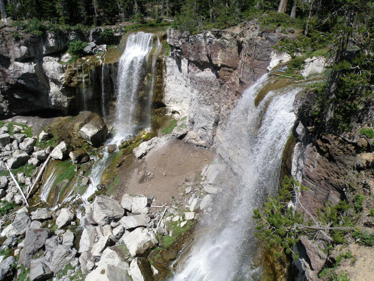
Paulina Creek Falls
- Region: South of Bend in Newberry National Volcanic Monument
- Height: Twin plumes dropping about 80 feet over a volcanic cliff.
- Trail: You have two main options: Short 0.5-mile RT path from the upper viewpoint lot, or the 1.8-mile RT hike with ~240 feet gain if you walk from the main trailhead.
- Difficulty: Easy–moderate depending on route.
- Access & Parking: Monument day-use fee or federal pass required; paved road generally open June–October.
- Best Season: Summer–early fall.
There are waterfall hikes — and then there are waterfall hikes inside an ancient volcanic caldera. Paulina Creek Falls delivers both drama and uniqueness, with twin streams cascading 80 feet over a cliff edge in a thunderous display that feels almost too perfect to be real.
I first visited Paulina Creek Falls during a summer road trip through Central Oregon, and it quickly became one of my favorite easy-access hikes in the region. The trail to the upper viewpoint is short and shaded, making it ideal even on warm days. From the overlook, you get a panoramic view of the twin falls dropping into the volcanic rock amphitheater below — it’s breathtaking, especially at golden hour.
For more of an adventure, you can follow the side trail down to the base (steep and a bit slippery), where you’ll feel the mist hit your skin and hear the echo of water off the lava walls. It’s the kind of place that’s beautiful in photos, but unforgettable in person.
Pro Tip: Pair this hike with a soak in nearby Paulina Lake Hot Springs — it’s the perfect way to wind down after chasing waterfalls.
👟 Family-Friendly Waterfall Hikes
Your knees will be fine. Your camera roll will not.
Latourell Falls
- Region: Columbia River Gorge
Trail Stats: Loop of ~2–2.4 miles, ~600–625 feet gain.
Height: 249 feet - Difficulty: Easy–moderate; some climbing but family-friendly.
- Access & Parking: Small state park lot just off the highway, usually fills on nice weekends. No pass required.
- Best Season: Year-round, but especially lush in spring and fall.
Latourell Falls is the kind of hike that makes you stop mid-trail just to take it all in — and then immediately grab your camera. It’s one of the closest major waterfalls to Portland, but somehow still feels like a hidden gem compared to its more famous neighbor, Multnomah Falls.
What sets Latourell apart is its striking yellow-green lichen-covered basalt cliffs. I remember rounding a bend and seeing the falls for the first time — a single, powerful drop framed by vivid rock that looked almost painted. Even with others around, it felt cinematic.
The full loop hike is a must if you have time. It takes you past the upper falls, through fern-filled forest, and across charming wooden bridges that make you feel like you’re in a Pacific Northwest storybook. But even if you just do the shorter out-and-back to the lower falls, the payoff is huge.
Pro Tip: Wear grippy shoes — the misty spray and moss can make some parts of the trail slick, especially near the base viewpoint.
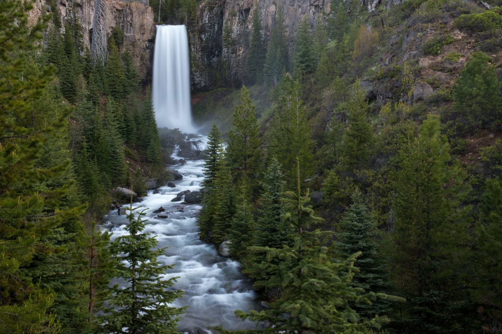
Tumalo Falls
- Region: Deschutes National Forest, west of Bend
- Height: ~97 feet.
- Difficulty: Easy for the overlook; moderate for the longer loops.
- Access & Parking: Tumalo Falls Day Use Area, narrow road with limited parking; 27-foot vehicle length limit and a recreation pass or day fee required.
- Best Season: Late spring–fall when the road is open and snow-free.
The main viewpoint is just a short walk from the parking lot, but the moment you see the 97-foot waterfall crashing over a basalt cliff into a pine-fringed canyon, it feels like you’ve stepped into a postcard.
I visited Tumalo early one June morning, and the light filtering through the trees made the mist around the falls glow. It was quiet except for the roar of the water and the occasional birdcall — pure Central Oregon serenity. If you’re short on time or traveling with kids, the viewpoint alone is worth the stop.
But if you have a few hours and sturdy shoes, continue on the North Fork Trail. You’ll follow the creek past several smaller, equally lovely falls and get a deeper feel for the high desert-meets-alpine vibe that makes this area so special.
Pro Tip: The road to the trailhead is gravel and can get washboarded — drive slow and arrive early for parking (it fills up fast in summer).
Tamanawas Falls
- Region: Mount Hood National Forest, near Highway 35
- Height: ~100 feet.
- Trail: 3.4 miles round-trip, ~300–600 feet gain depending on source; generally a moderate forest and creek hike.
- Difficulty: Easy–moderate; some rocks and roots, plus light scrambling if you go behind the falls.
- Access & Parking: Tamanawas Falls trailhead off Highway 35; NW Forest Pass or America the Beautiful Pass required.
- Best Season: Late spring–fall; snow lingers into early summer.
Tamanawas Falls feels like a reward waiting patiently at the end of a forested tunnel. The trail winds through a fairytale landscape — towering Douglas firs, mossy boulders, and the sound of rushing water growing louder with every step. By the time the 100-foot waterfall bursts into view from a lava cliff, it feels like you’ve discovered something ancient and sacred.
I hiked Tamanawas Falls in early summer, when the creek was full and the air was warm but still crisp beneath the forest canopy. It’s not a hard trail, but it asks you to pay attention — slick stones and tree roots keep it interesting. The final approach opens suddenly, revealing the falls tucked into a moss-draped canyon that looks like it was carved just for quiet awe.
If you’re willing to scramble a bit (carefully!), you can get close enough to feel the spray and hear nothing but the echo of falling water. It’s a waterfall that rewards stillness — and a perfect place to just sit, breathe, and listen.
Pro Tip: Go early in the day or on a weekday. This trail has become more popular in recent years, and solitude makes it even more magical.
Proxy Falls
- Region: Willamette National Forest off OR-242 (McKenzie Pass)
- Height: Lower Proxy is ~226 feet in a lacy veil.
- Trail: 1.6 mile loop, ~170–250 feet gain, with short spurs to Lower and Upper Proxy.
- Difficulty: Easy; roots and lava rock but very manageable.
- Access & Parking: Small trailhead lot off the McKenzie Pass highway; road usually open late June–October only.
- Best Season: Summer–early fall when the pass is open.
Some waterfalls feel like they’re trying to impress you. Proxy Falls doesn’t try — it just is. Towering at 226 feet, this moss-draped cascade tumbles down a lava rock cliff with an effortless elegance that feels both wild and dreamlike. It’s not just one of the most photogenic falls in Oregon — it’s one of the most immersive.
I visited Proxy Falls during a quiet September afternoon, and even with a few cars in the lot, the trail felt surprisingly serene. The loop winds through a lava field and shaded forest, and then suddenly opens up to one of the most breathtaking waterfall views I’ve ever seen. You’ll hear it first — a distant roar that builds as you get closer — and then the entire wall of water appears in front of you, framed by emerald moss and dripping branches.
The trail splits to two viewpoints: the upper view is easy and dry, while the lower viewpoint involves a short scramble over wet rocks — but worth it. Standing at the base, with spray cooling your face and mist catching the light, feels like walking into a fantasy novel.
Pro Tip: Bring a waterproof jacket and a wide-angle lens — you’ll want both. And don’t forget to check road conditions; Highway 242 closes seasonally and access depends on snowmelt.
Sweet Creek Falls
- Region: Coast Range southeast of Florence, near Mapleton
- Height: Series of small cascades, with Sweet Creek Falls as the main drop.
- Trail: Up to ~5.2 miles RT with 650 feet gain if you connect all segments; most people do a shorter ~2–2.5 mile out-and-back to the main falls.
- Difficulty: Easy; some narrow, wet sections on catwalks above the creek.
- Access & Parking: Several small trailheads along Sweet Creek Road; no pass currently required.
- Best Season: Year-round; winter/spring for big flow, fall for foliage.
Unlike the dramatic plunges of some Oregon waterfalls, Sweet Creek is all about movement: a series of lively cascades that dance through mossy ravines, culminating in a wide, picturesque main drop that’s as calming as it is beautiful.
I hiked this trail after a light rain, and it was like walking through a living postcard. Ferns glistened. The air smelled of cedar and damp earth. And the trail? Gentle and inviting, with wooden bridges and creekside views almost the entire way. What I loved most was how accessible it felt — no major climbs, no rocky scrambles — just nature showing off in slow motion.
The multiple viewpoints along the way keep you engaged, and if you take your time (like I did), you’ll notice wildflowers blooming in spring and countless photo ops around every bend. It’s one of those rare hikes that’s peaceful, not crowded, and still packed with “wow” moments.
Pro Tip: Start early to enjoy the solitude, and wear waterproof shoes — there are wet spots along the trail, even in dry weather.
Shellburg Falls
- Region: Santiam State Forest northeast of Salem
- Height: ~100+ feet (tall horsetail fall).
- Trail: A mix of options since the 2024 re-route; Upper Shellburg Falls trail is ~1.4 miles RT, or ~4.8 miles if you combine upper and lower routes, ~400 feet gain.
- Difficulty: Easy–moderate.
- Access & Parking: New trailhead and small day-use area; no pass required as of 2024.
- Best Season: Spring for best flows and wildflowers; accessible most of the year.
Shellburg Falls is one of those places that makes you feel like you’ve stumbled onto a local secret — even though it’s hiding in plain sight just a short drive from Silver Falls State Park. The trail winds through forest and farmland before dropping you into a hidden canyon where the real magic happens.
What makes Shellburg stand out? You can walk behind the falls. I remember the first time I did — the sound of water crashing just feet from my back, the cool mist on my arms, and the dark, mossy cavern behind the cascade made it feel like I’d been let in on some enchanted secret.
The trail itself is moderate, with a few steep or muddy patches depending on the season, but nothing too intense. Along the way, you’ll pass wildflowers in spring, a peaceful creek, and even a few curious cows if you’re hiking from the lower trailhead near private land. It’s a fun blend of working forest and wild nature.
Pro Tip: This area is part of a working timber zone — check ahead for closures, and go after a rainy week for the fullest flow.

Sahalie & Koosah Falls Loop
- Region: Off OR-126 along the McKenzie River
- Heights: Sahalie ~100 feet; Koosah ~70 feet.
- Trail: 2.4–2.6 mile loop, ~360–380 feet gain, connecting both falls along the river.
- Difficulty: Easy–moderate; some stairs, roots, and short climbs.
- Access & Parking: There is parking at both falls with very short viewpoint walks if you don’t want the full loop.
- Best Season: Mid-spring through fall; flows are big in spring, but trail can be slick.
Few hikes in Oregon deliver this much beauty in this short a distance. The Sahalie & Koosah Falls Loop feels more like a string of scenic surprises than a single trail. Rushing blue water, old-growth forest, moss-draped lava rocks — and of course, two stunning waterfalls just minutes apart.
I first hiked this loop during a hot July afternoon, and the cool spray from the falls was like nature’s air conditioning. Sahalie hits you right away — a thunderous, frothy blast of white water tumbling down basalt cliffs. It’s powerful, loud, and impossible to ignore. Just when you think that was the showstopper, Koosah Falls appears a mile later, elegant and layered like a veil dropping into a deep turquoise pool.
The trail connects the two falls in a scenic loop along the McKenzie River. You’ll pass through lush forest, cross rustic wooden bridges, and hear the river the whole way. It’s well-marked but can be uneven — I’ve slipped a few times on wet roots, so good hiking shoes are a must.
Pro Tip: Hike clockwise for a more gradual climb and better photo angles of both falls — especially if you’re chasing morning light.
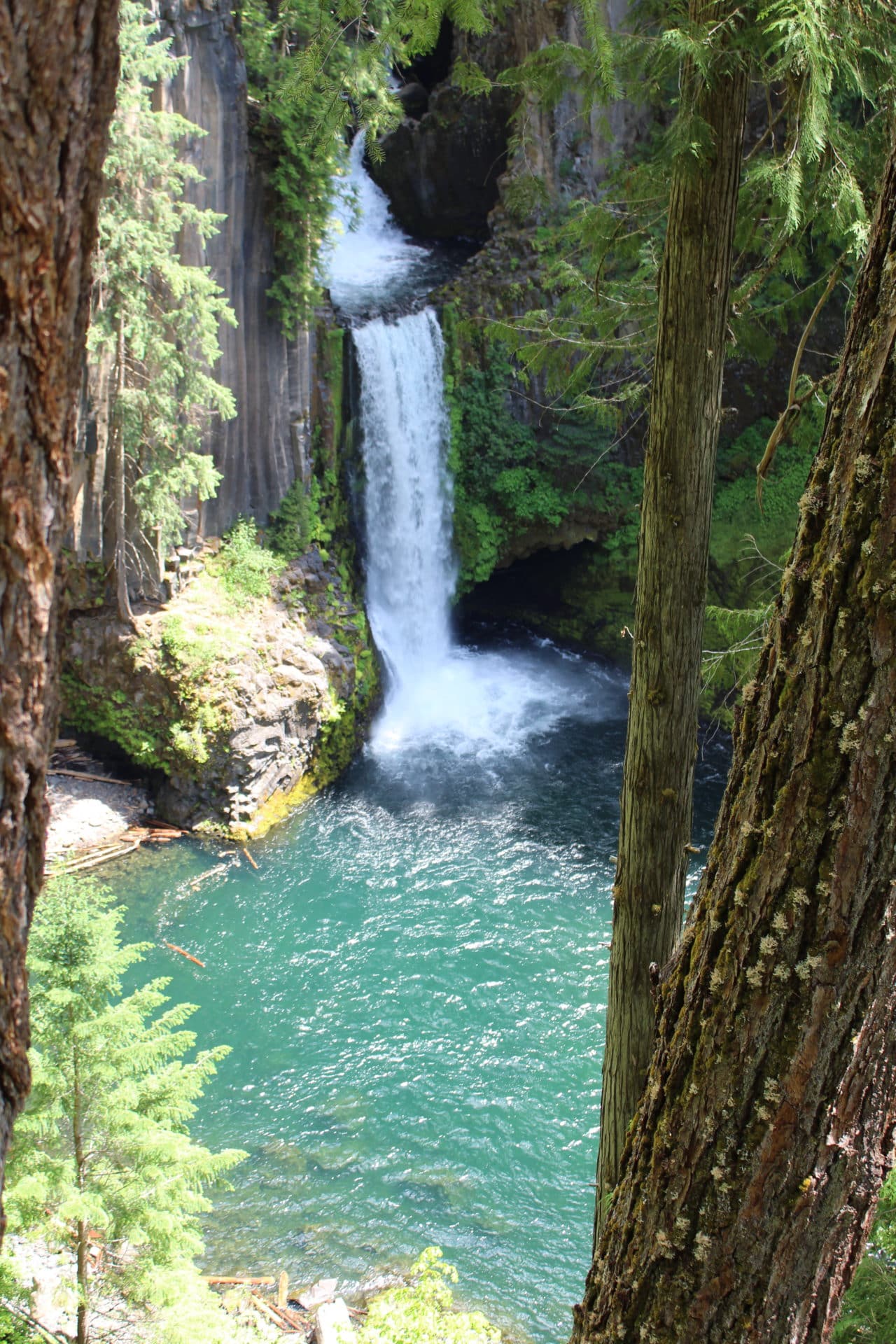
Toketee Falls
- Region: Along OR-138 east of Roseburg
- Height: ~113–120 feet total in two tiers.
- Trail: ~0.8 miles round-trip, ~120–200 feet gain.
- Difficulty: Easy–moderate (short, but stairs).
- Access & Parking: Signed Toketee Falls trailhead off Highway 138; pit toilet, small lot.
- Best Season: Spring–fall; access road can be snowy/icy in winter.
I’ll never forget the first time I stood at Toketee Falls — it was like opening a book and walking straight into a fantasy novel. The basalt columns lining the falls make the whole scene feel sculpted by hand, like nature paused time just to create this one perfect view. Even the short trail builds anticipation: you can hear the thunder of the waterfall long before you see it.
The trail itself is easy and well-maintained, with a few stairs near the end. It’s family-friendly and perfect if you’re not looking for a strenuous hike but still want that jaw-dropping reward. I went in late May when the flow was at its strongest, and the viewing platform gave a wide, unobstructed look at the twin-drop falls without needing to scramble or get too close to the edge.
Pro Tip: Arrive early or late in the day — it’s a popular stop, but the golden light through the trees at sunrise or sunset makes it feel private and cinematic.
Did you know? OR-138 is the official Oregon Road of Waterfalls. Read my article about it here.
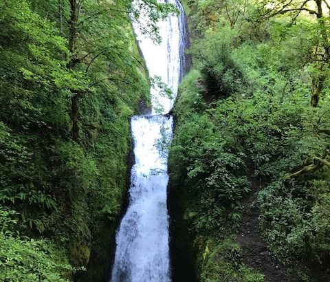
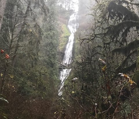
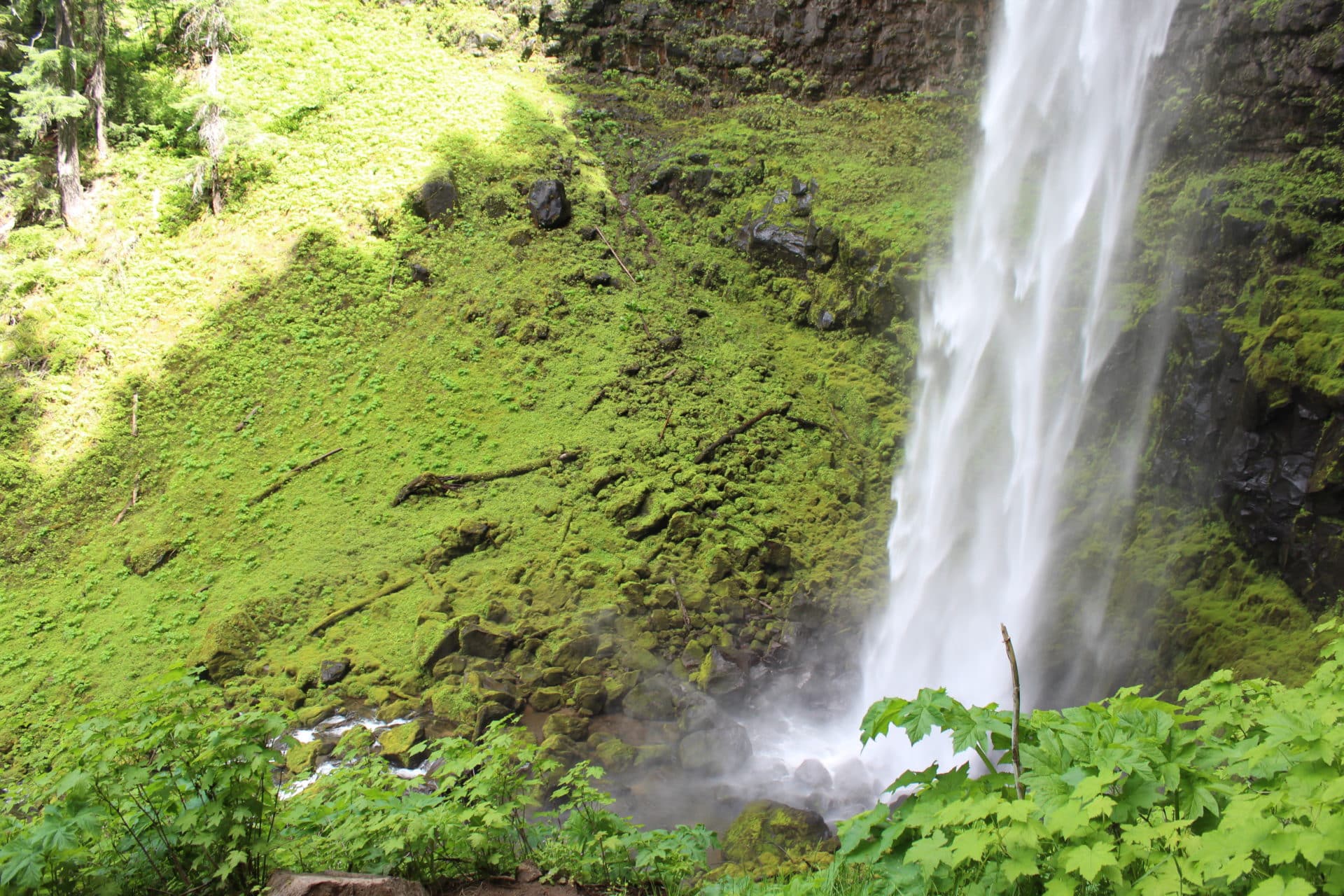
Watson Falls
- Region: Umpqua National Forest near Toketee
- Height: ~272–294 feet, one of the tallest in Oregon.
- Trail: ~0.8–1 mile loop, ~400–430 feet gain.
- Difficulty: Easy–moderate; short but notably steep with many stone steps.
- Access & Parking: Signed trailhead and picnic area along Highway 138.
- Best Season: Spring–early summer for big flow; accessible most of the year.
At 272 feet, it’s one of the tallest waterfalls in Oregon, and standing near the base is like witnessing a force of nature that’s louder, wilder, and more powerful than you expected.
The trail may be short, but don’t underestimate it — it climbs fast through switchbacks and slick sections. I hiked it just after a spring rain, and while the path was a bit muddy, the falls were in full, thunderous flow — totally worth the extra effort. As I reached the upper viewing platform, the roar of the water echoed off the canyon walls, and I could feel the mist cutting through the air like fog on a cold morning. It was all-consuming — in the best way.
There’s a sense of scale here that photos just can’t capture. The moss-covered boulders, the steep basalt cliffs, the dramatic plunge — Watson Falls feels untamed and cinematic, like a hidden backdrop from an adventure film.
Pro Tip: Wear shoes with good tread and bring a rain shell, even on dry days — the spray near the base is no joke.
South Falls (Silver Falls State Park)
- Region: Silver Falls State Park, east of Salem
- Height: ~177 feet, classic curtain you can walk behind.
- Trail: Take the Short ~1-mile loop from the South Falls day-use area, or hike the full 7.2-mile Trail of Ten Falls loop with ~800–1,000 feet gain.
- Difficulty: Easy for the little loop; moderate for the full circuit.
- Access & Parking: Large but busy lots; state park day-use fee required.
- Best Season: All year; winter and early spring for roaring water, fall for foliage.
South Falls is the crown jewel of Silver Falls State Park — and it’s easy to see why. It’s not just the height (177 feet) or the volume of water. It’s the experience of walking behind the falls, stepping into a natural amphitheater where the world goes quiet except for the steady roar of water pouring from above.
I first hiked South Falls one autumn when the leaves were just starting to turn. The air was crisp, and the contrast between the golden foliage and the silver curtain of water made the whole scene feel surreal. Even though it’s one of Oregon’s most photographed waterfalls, it still manages to feel personal and awe-inducing, especially when you’re standing behind the veil and watching the forest blur beyond it.
If you’re short on time, the 1-mile loop gives you the full behind-the-falls magic without a major commitment. But if you want to go all in, the full Trail of Ten Falls loop connects you with even more waterfalls, viewpoints, and lush canyon scenery.
Pro Tip: Visit midweek or during the shoulder seasons for fewer crowds — and don’t forget a rain jacket if you’re planning to walk behind the falls. You will get misted.
⛰️ Serious Waterfall Missions
For the hikers who read “exposure” and think “fun!”
Abiqua Falls
- Region: Cascade foothills east of Salem
- Height: ~92 feet in a basalt amphitheater. Pines and Vines+1
- Trail: 0.7–1+ miles RT depending on where you park, steep and rooty with rope assists. Pines and Vines+2AllTrails.com+2
- Difficulty: Moderate–strenuous because of the steep scramble, mud, and slick rocks.
- Access & Parking: Rough, rutted road; lower trailhead requires high-clearance 4WD. Many people park higher up and walk the road down.
- Best Season: Late spring and early summer; road and trail can be sketchy in deep mud or ice.
Abiqua Falls feels like a secret whispered by the forest — hidden down an unmarked road, accessed via a slippery trail, and revealed with the kind of drama that makes you gasp. Nestled in a basalt amphitheater and crashing into a jade-green pool, it’s one of Oregon’s most stunning waterfalls — and one of the most rewarding to reach.
I made the trek in spring, sliding through mud and holding onto tree roots like handrails. The trail is more of a scramble in parts, and ropes are tied along the steepest sections (they help, but still — bring caution and good shoes). But the moment you reach the base, it’s like the rest of the world falls away. The falls thunder down 92 feet over lava rock columns, and the canyon walls wrap around you like a cathedral of moss and mist.
It’s wild. It’s not polished or easy. And that’s part of what makes it unforgettable. This is not a hike for flip-flops!
Pro Tip: A high-clearance vehicle is recommended for the rough access road. And always check current access rules — the trail crosses private land and conditions can change.
Downing Creek Falls
- Region: Near Highway 22, southeast of Salem, between the Willamette NF and Mt. Hood NF
- Height: Picturesque multi-tier cascade tucked in the forest.
- Trail: Around 1 mile RT, ~200–300 feet gain, short but can be slippery.
- Difficulty: Moderate because of rough tread, mud, and roots.
- Access & Parking: Informal pull-off along Highway 22; unsigned path leads toward the creek.
- Best Season: Late spring–early summer for strong flow; trail can be brushy later in the season.
If you’ve ever dreamed of having a waterfall all to yourself, Downing Creek Falls might just grant that wish. Hidden away in a remote stretch of the Willamette National Forest, this is one of those rare spots that feels untouched, unspoiled, and almost entirely unknown — even among locals.
I first hiked to Downing Creek Falls after hearing about it from a ranger who said, “You’ll probably have it to yourself.” He was right. The trail is unmaintained and unmarked, winding quietly through lodgepole pines until you hear the gentle thunder ahead. And then — there it is — fanning out like a silvery curtain over black rock, framed by moss and stillness.
It’s not a dramatic plunge or a towering drop, but there’s something deeply peaceful about it. I sat by the edge for nearly an hour, shoes off, listening to the soft rush of water and feeling like I’d stumbled onto a secret Oregon keeps tucked in its back pocket.
Pro Tip: Bring GPS or download offline maps — the trail is unofficial and can be easy to miss. This is best for hikers who are comfortable with a bit of navigation and solitude.

Gorton Creek Falls
- Region: Near Wyeth / Viento area of the Gorge
- Height: ~100+ feet, tucked at the head of a mossy gorge.
- Trail: About 1.5 miles RT, ~150 feet gain, but the upper section is boulder-hopping up the creek.
- Difficulty: Easy to Emerald Falls; moderate and scrambly from there to Gorton Creek Falls.
- Access & Parking: Wyeth trailhead area just off I-84; NW Forest Pass / federal pass required in season.
- Best Season: Spring–early summer; rocks can be slick year-round.
You’ll follow a creek up a moody, glowing-green canyon until the falls suddenly appear. It feels wild and uncrowded compared to the “main” Gorge waterfalls.
Linton Falls
- Region: Just off OR-242 near Linton Lake, Three Sisters Wilderness
- Height: Main cascade is over 600 feet total drop, with a lower ~80-foot tier.
- Trail: Start on the Linton Lake Trail (about 4.3–4.5 miles RT, ~650 feet gain) then continue on an unmaintained, very steep user path/bushwhack to the falls.
- Difficulty: Strenuous and hazardous; not for beginners.
- Access & Parking: Linton Lake trailhead on OR-242; highway closed in winter/spring due to snow.
- Best Season: Summer when the highway is open and slopes are snow-free.
Tucked into the mossy folds of the Columbia River Gorge, this 115-foot waterfall waits at the end of a rough, wet scramble that rewards the bold.
I followed the faint path upstream on a warm June morning, where the official trail quickly fades and the real journey begins — rock-hopping, navigating slick logs, and wading through cold, clear water with sunlight dancing through the canopy. It’s not a hike for casual strollers, but if you’re up for the challenge, the payoff is pure magic.
The waterfall itself spills over a sheer basalt wall in a narrow, powerful stream, surrounded by emerald moss and complete silence — except for the sound of water echoing through the canyon. I stood there soaked, a little scraped up, and absolutely in awe. It felt like nature’s version of a reward for those willing to go off script.
Pro Tip: Wear water shoes or grippy hiking boots and expect to get wet. This hike isn’t marked and requires comfort with off-trail terrain. Not suitable during high water or after heavy rain.
Twister Falls
- Region: Eagle Creek Trail, Columbia River Gorge
- Height: ~140 feet total, with the distinctive “twisting” double stream.
- Trail: Roughly 12 miles RT, ~1,600 feet gain from the Eagle Creek trailhead to Twister Falls, passing several other famous falls along the way.
- Difficulty: Moderate–strenuous due to length, narrow cliff-side sections, and exposure.
- Access & Parking: Eagle Creek trailhead near Cascade Locks; historically extremely popular and subject to closures after fires/landslides—always check current conditions.
- Best Season: Late spring–fall when the trail is in good condition; avoid icy periods.
Twister Falls doesn’t just tumble — it spirals. This waterfall earns its name from the wild, double-helix drop that makes it look like water is braiding itself down the cliff. And getting there? It’s half the magic.
The hike in via the Eagle Creek Trail is nothing short of iconic. Sheer drop-offs, mossy canyon walls, and narrow ledges carved into the cliffs keep your heart thumping in the best way. I remember clinging to the cable handrails on the exposed sections, heart racing — and then getting completely distracted by the views. You pass Tunnel Falls on the way (yes, through an actual tunnel behind a waterfall), and just when you think the show is over, Twister Falls stuns you with its perfect, twisty elegance.
I sat down on a rock overlooking the falls and just stared — not talking, not thinking, just watching water bend in ways I didn’t know it could. It’s the kind of place you don’t want to leave, and one that stays with you long after you hike out.
Pro Tip: Not recommended for those with a fear of heights. Wear shoes with excellent traction, and don’t attempt during or after heavy rain — this trail requires full attention.
Final Thoughts
Oregon does waterfalls like nobody else — mossy, moody, dramatic, and packed with adventure. Each of these hikes offers something different — the thrill of scrambling to a hidden viewpoint, the quiet awe of standing behind a curtain of water, or the kind of solitude that resets your whole nervous system.
I’ve wandered these trails soaked, sunburned, smiling, and sometimes speechless. And I promise: whether you’re an experienced hiker or just looking for a weekend escape, there’s a waterfall on this list that will meet you exactly where you are — and then blow you away.
So lace up your boots. Pack a rain shell. And go let Oregon work its magic.
If you’re planning a trip to Oregon or building your dream trail bucket list, don’t forget to bookmark this post, share it with your adventure crew, or subscribe for more Pacific Northwest trail inspiration.