The Columbia River Gorge isn’t just a scenic drive — it’s a hiker’s paradise that locals like me keep coming back to, season after season. As someone who’s lived in Oregon most of my life and hiked these trails more times than I can count, I can tell you: there’s nothing like stepping into this landscape on foot. From misty waterfall loops to quad-burning climbs with sweeping views, the Gorge offers something for every kind of adventurer.
Spanning the border between Oregon and Washington, the 80-mile Columbia River Gorge carves its way through the Cascade Range, creating a natural playground that’s as diverse as it is stunning. It is, without a doubt, one of the best scenic drives in the United States. But the hiking is even more spectacular. On two feet, one can take in the grandeur of mother nature more slowly. Savor it. And get into the nooks and crannies that a motor vehicle would never reach.
In this guide, I’m sharing the best hikes in the Columbia River Gorge — the ones I return to year after year. You’ll find trails for all skill levels, waterfall-packed routes, epic summit views, and tips from someone who’s actually walked them (often more than once). Whether you’re planning your first visit or looking for a fresh trail to explore, this list will help you pick the perfect hike for your next Gorge getaway.
Hiking in the Columbia River Gorge (with Waterfalls!)
With altitudes ranging from sea level to mountains towering over 4,000 feet, the Gorge offers a panorama of ecosystems. From lush, temperate rainforests to arid grasslands, every step promises a new scene. It’s this unparalleled variety that makes the Gorge a world-class destination for hikers of all skill levels. Whether you’re a beginner looking to soak in some scenic views, or an experienced trailblazer craving some serious elevation gain, there’s a path here that feels custom-tailored just for you.
Wahkeena Falls Loop Trail – Serenity Now!
- Length: 5.1 miles
- Elevation Gain: 1,640 feet
- Difficulty: Moderate
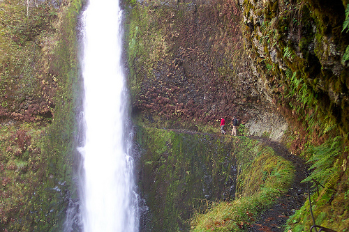
Kick things off with a splash at Wahkeena Falls Loop Trail. With a moderate hike distance that rewards you with a front-row seat to cascading falls, this loop is a picture-perfect start to your Gorge explorations.
Yes, but what about the trailhead, you say? You’ll find it whispering your name off the Historic Columbia River Highway, not too far from Multnomah Falls, making it super accessible for everyone coming from Portland.
Starting off, the trail greets you with a gentle mist from the majestic Wahkeena Falls, a sight so serene it feels like stepping into a postcard. You’ll meander through lush forests, cross charming footbridges, and catch your breath (because the views will steal it) at panoramic vistas of the Columbia River Gorge.
Beacon Rock – 360 View Goodness
- Length: 1.8 miles
- Elevation Gain: 680 feet
- Difficulty: Moderate
Not afraid of heights? Then Beacon Rock is calling your name! Strap in for a 360-degree view that’ll knock your socks off. It’s only 1.8 miles, but with views like this, you’ll never want to leave. Plus, you’ll feel like a real-deal mountaineer conquering this 848-foot rock face.
The trail kicks off on the Washington side of the Columbia River Gorge, a mere stone’s throw away from the Bridge of the Gods. From the moment you set foot on the trail, you’ll notice that it’s thoughtfully constructed, with switchbacks and handrails guiding you safely upwards. And trust me, the payoff is worth every step.
Want even more waterfalls? Here are the 20 Best Waterfall Hikes in Oregon.
En route to the summit, you’re treated to a variety of scenic delights. The dense forests give way to open areas where you can admire the grandness of the Gorge, watch the mighty Columbia River flowing beneath, and if you’re lucky, catch sight of majestic eagles soaring above.
Beacon Rock State Park makes accessing this hike incredibly smooth. Look for the well-marked parking area off Highway 14, and you’re at the trailhead. Remember, the park might require a Discover Pass, so check the latest requirements to ensure your entrance is as smooth as your hike will be.
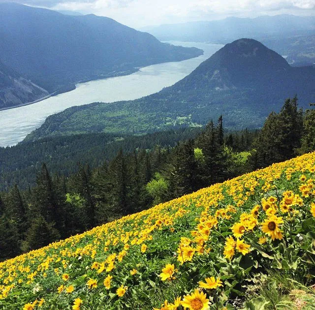
Dog Mountain – Stunning Vistas
- Length: 6.9 miles
- Elevation Gain: 2,800 feet
- Difficulty: Difficult
Dog Mountain is an uphill battle, but once you tackle those switchbacks, you’re rewarded with a sea of blooms and vistas for days. Spring, of course, steals the show with its explosive display of wildflowers. The mountain’s slopes are painted with the vivid yellows of balsamroot, the delicate purples of lupine, and a rainbow of other wildflowers that seem to burst into life as if by magic.
In the summer, the greenery is lush and inviting, offering a cooler respite from the valley’s heat. Come fall, the landscape is a riot of colors, with fiery maples and amber oaks standing out against the evergreens.
The trailhead for Dog Mountain is conveniently located along Highway 14, about 12 miles east of Stevenson, Washington. You’ll know you’re in the right place when you see the expansive parking area and the trailhead sign, beckoning adventurers with the promise of nature’s splendor.
Just a word of wisdom – the hike is popular, especially on weekends during the wildflower peak season, so an early start is advisable to secure parking and enjoy the trails with fewer fellow hikers.
Table Mountain – Hike Part of the PCT
- Length: 15.5 miles
- Elevation Gain: 4,320 feet
- Difficulty: Difficult
For the hike-savvy folks, Table Mountain is your high-stakes poker game. It’s a tough one, but what’s adventure without a little risk? The pinnacle moment is reaching the summit where the valley stretches out like a green carpet just for you.
On the trek, prepare to have your breath taken away, and I’m not just talking about the workout! This hike is a treasure trove of geological marvels and panoramic viewpoints. Starting at the Bonneville Trailhead, the climb includes intriguing basalt formations – think nature’s own sculptures – and surreptitiously hidden waterfalls that create serene oases, perfect for a contemplative break or a photo op.
Then, there’s the summit. Reaching it feels like stepping onto an elevated stage with the Columbia River Gorge as your audience. The 360-view is nothing short of spectacular, allowing hikers to gaze upon the vast expanse of verdant landscapes, the winding river, and the peaks of distant mountains.
Getting to the trailhead is a cinch. You’ll find the Bonneville Trailhead snug between the proud towering trees, just off I-84 by taking exit 40.
Rowena Crest – Insta-famous
- Length: 1 mile
- Elevation Gain: 100 feet
- Difficulty: Easy
For those who are more about the view than the sweat, Rowena Crest offers a less strenuous path with the same visual treat. The hike is truly a photographer’s dream and a nature enthusiast’s playground. What sets Rowena Crest apart, especially during spring, is its lavish carpet of wildflowers.
Finding the McCall Point trailhead is easy – it’s located near the small town of Mosier, just off the Historic Columbia River Highway. You’ll see the clearly marked parking area on the right, ready to welcome you into this slice of Pacific Northwest heaven.
Grab your camera, your loved ones, or just your thoughts – Rowena Crest is waiting to offer you a tranquil escape from the hustle and bustle of daily life.
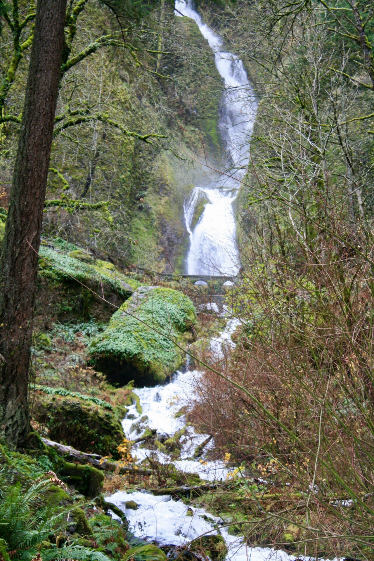
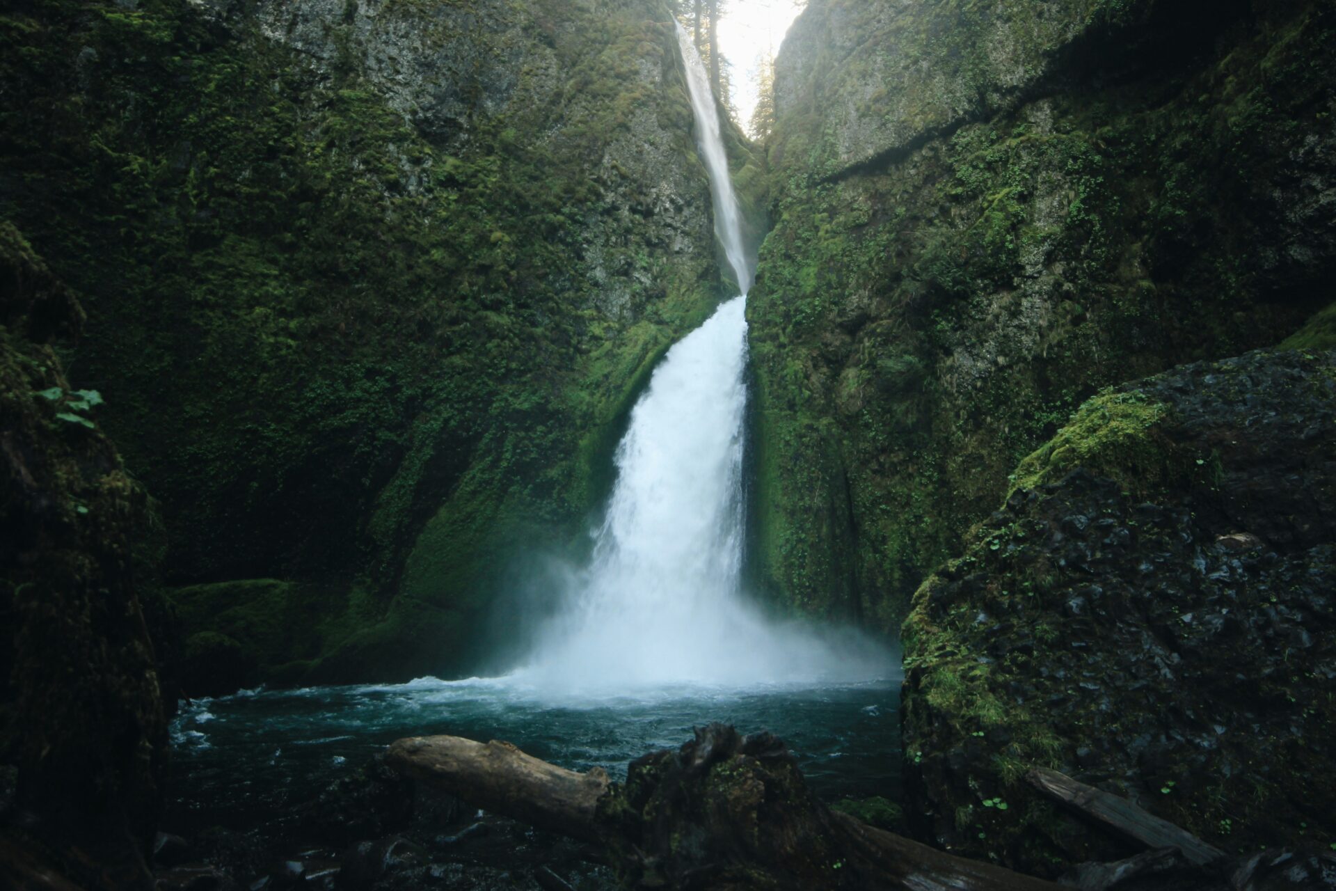
Wahclella Falls – Intimate Beauty
- Length: 2 miles, loop
- Elevation Gain: 250 feet
- Difficulty: Easy
As you make your way on this 2-mile round trip adventure, you’ll meander alongside Tanner Creek, feeling its cool, misty spray as you draw closer to the falls. What’s unique about Wahclella is the sense of intimacy it offers, as the trail wraps you in the arms of ancient trees and guides you through a verdant, mossy enclave that seems untouched by time.
The crescendo of your hike is the stunning Wahclella Falls itself. This two-tiered waterfall cascades majestically into a serene basin, creating a dynamic and invigorating spectacle that’s both awe-inspiring and deeply calming.
To start your quest to Wahclella Falls, head towards the Bonneville Dam in the Columbia River Gorge. The trailhead is conveniently located off exit 40 on the I-84, marked by signs that lead you to the parking area. From there, the path to natural magnificence is well-marked and beckons to all who seek the solace and exhilaration only nature can provide.
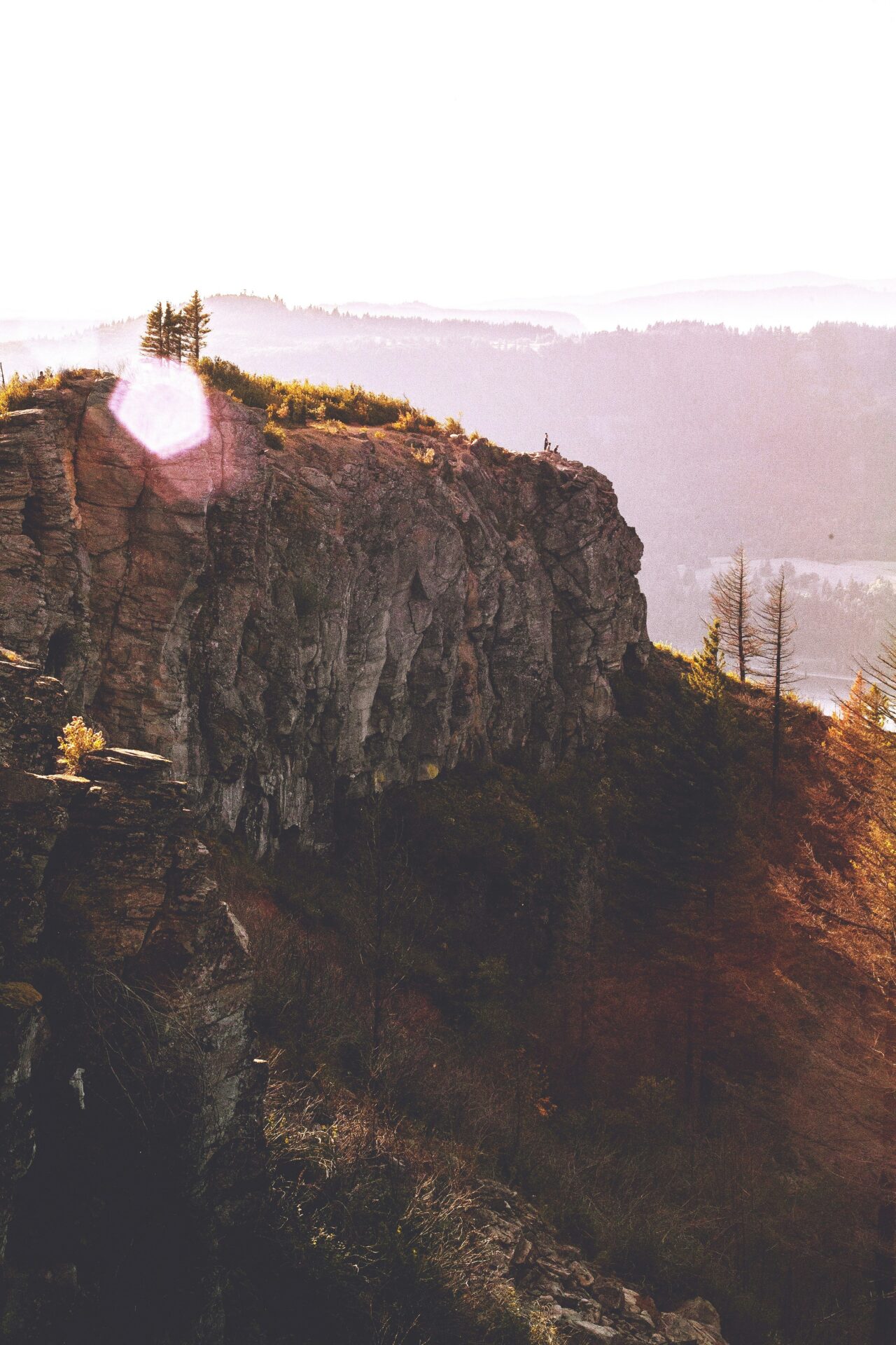
Angel’s Rest – A Bird’s Eye View
- Length: 4.8 miles, out and back
- Elevation Gain: 1,450 feet
- Difficulty: Moderate to Difficult
Now, if you want to see what the Gorge looks like from a bird’s POV, Angel’s Rest is it. Prepare to be dazzled as you venture on a 4.8-mile round-trip that will challenge and reward you in equal measure. This trek gains about 1,500 feet in elevation, but every step upwards brings a new perspective of the breathtaking Columbia River Gorge.
Along the way, you’ll traverse switchbacks flanked by towering Douglas firs and delicate wildflowers, particularly vibrant in the spring. The path may be rigorous, but the vistas are a constant source of inspiration, with each turn offering a snapshot-worthy view.
Finding the trailhead to this majestic experience is simple. Head to the town of Bridal Veil, off the Historic Columbia River Highway (US-30), and look for signs pointing to Angel’s Rest. Parking is available right at the trailhead, just be sure to grab your spot early or in the off season, as this trail is popular.
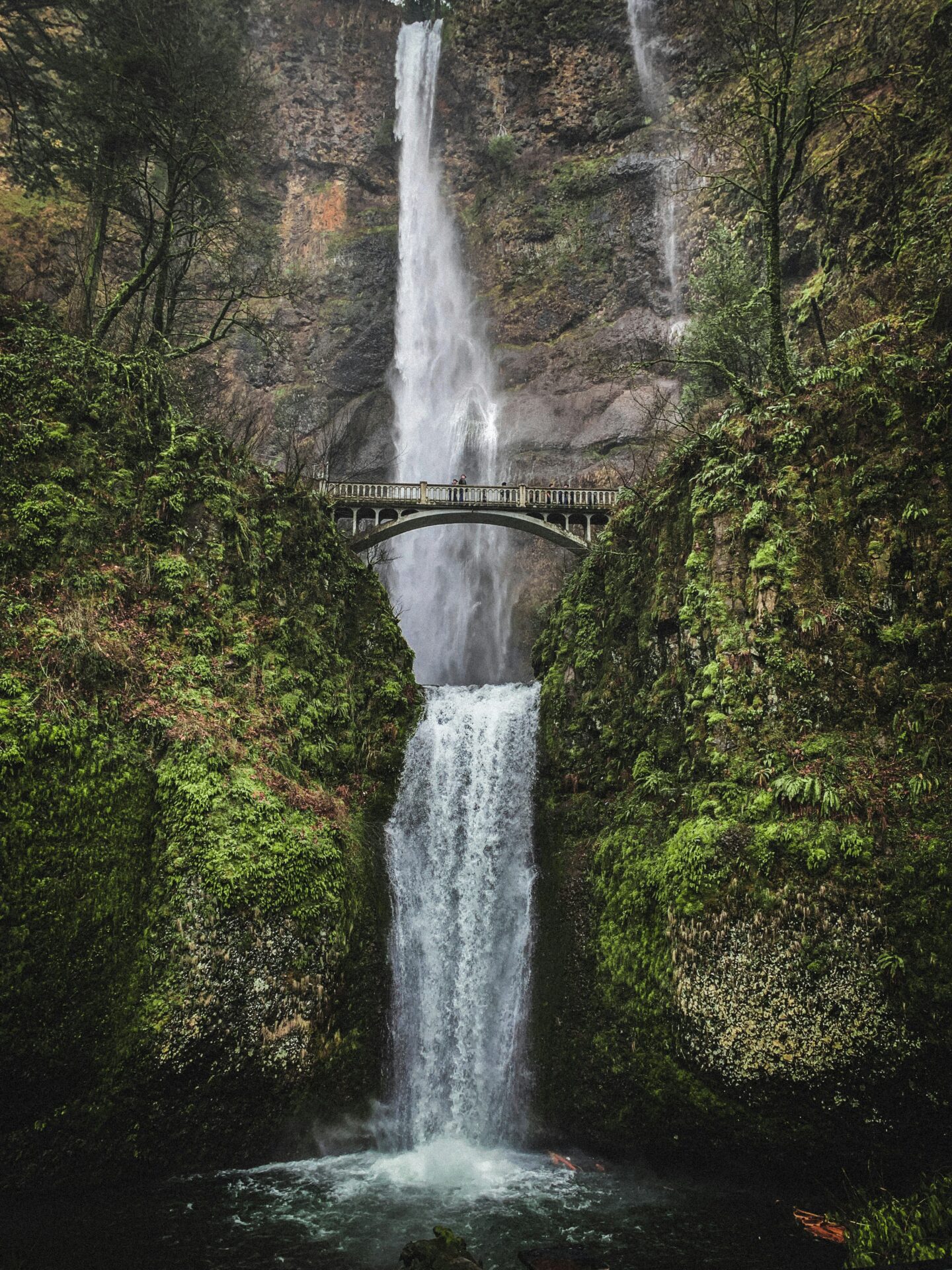
Multnomah Falls Hike – Oregon’s Tallest Waterfall
- Length: 2.4 miles, out and back
- Elevation Gain: 870 feet
- Difficulty: Moderate
This majestic waterfall, which is the tallest in the state, provides an awe-inspiring backdrop for one of the most beloved hiking experiences in the region. The trail to the top of Multnomah Falls is a well-trodden path that offers more than just a workout; it’s a journey through lush greenery with the constant sound of rushing water to accompany you.
Multnomah Falls hiking includes the iconic Benson Bridge, where you can pause for a breathtaking view of the falls plunging down the basalt cliff. The trail continues to wind its way up, offering spots that provide panoramic views of the Columbia River Gorge.
Finding the trailhead for Multnomah Falls is as easy as the hike itself is rewarding. Conveniently situated just off the Historic Columbia River Highway, about 30 miles east of Portland, it’s accessible for adventurers of all kinds.
Multnomah Falls used to be easy to visit. You’d just park and start your adventure. Now, it has become so popular that timed visits are required during the summer peak season. But don’t let that stop you – this waterfall is almost required of any trip to Oregon. If you’re going in the summer months, choose an early morning weekday to get the best experience and avoid the crowds. Be sure to check for the latest information before heading out.
Latourell Falls Loop Trail – Family Fun
- Length: 2.4 miles
- Elevation Gain: 520 feet
- Difficulty: Easy to Moderate
Another treasure for the waterfall aficionados, Latourell Falls Loop Trail, dishes out basalt cliffs draped with an elegant water veil that’s absolutely selfie-worthy. As you set off on the Latourell Falls Loop Trail, you’re stepping into a verdant world where the air is fresh, and every corner holds a new delight. This loop is perfect for families, casual hikers, or anyone looking to immerse themselves in nature without a day-long commitment. One of the first eye-catchers on the trail is the viewing area for the magnificent Latourell Falls, where the water cascades directly over a cliff, creating a mesmerizing spectacle.
The trail wraps around, taking you through a lush landscape where the shades of green seem infinite. Keep an eye out for the smaller cascades along the way; though they play second fiddle to the main attraction, they add to the trail’s charm. Seasonal wildflowers add splashes of color to the greenery, creating a vibrant contrast that’s a feast for the eyes and a hit on Instagram.
Located in Guy W. Talbot State Park, the trail begins right off the Historic Columbia River Highway near Corbett, a scenic drive from Portland. Look for the Latourell Falls parking area, which is well-marked and offers plenty of space.
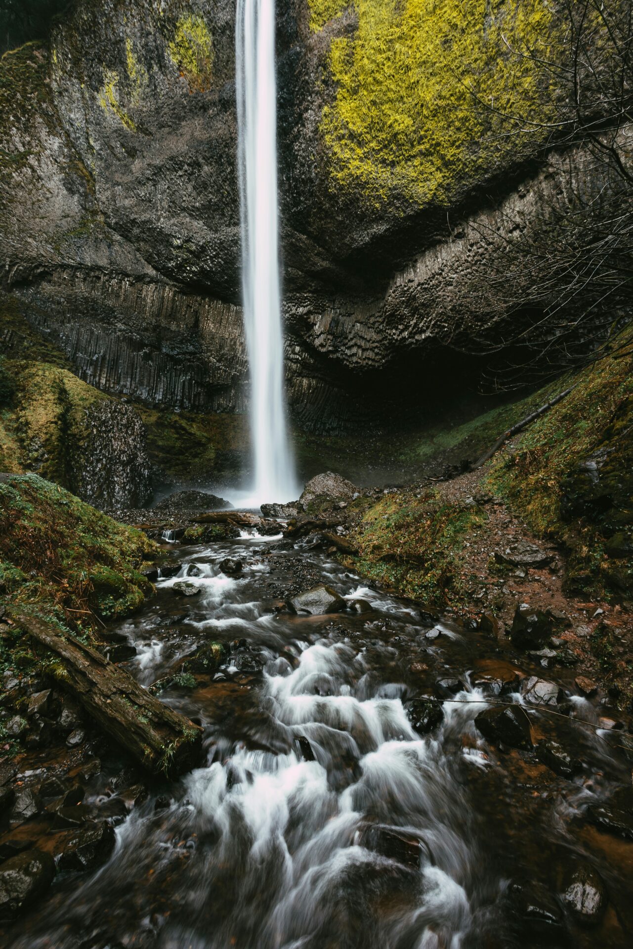
Eagle Creek to Tunnel Falls – Falls You Can Get Behind
- Length: 12 miles, out and back
- Elevation Gain: 1,775 feet
- Difficulty: Moderate to Difficult
For an adventure that’s as epic as its name, Eagle Creek to Tunnel Falls is your quest. Bridges, tunnels through rock – this trail has all the makings of a great saga, with the bonus of misty falls to cool you off after all that questing.
What truly sets this hike apart are the remarkable feats of nature and engineering you’ll encounter. The most iconic of these is the hand-carved tunnel behind Punchbowl Falls—a moment on the trail where you’ll literally walk through the heart of a waterfall, feeling the cool mist as you emerge on the other side.
The start of the hike is at the Eagle Creek Trailhead near Cascade Locks. It’s a popular starting point, so arriving early not only ensures a parking spot but also a more solitary communion with nature.
Larch Mountain – It’s a Doosy
- Length: 13.3 miles, out and back
- Elevation Gain: 4,055 feet
- Difficulty: Difficult
Lastly, for the grand finale, Larch Mountain. It’s not for the faint of heart, but hey, that’s not you, right? This hike is a perfect blend of effort and awe. You’ll pass through ancient forests that seem to whisper stories of the past, carpeted with a lush underlayer of ferns and wildflowers. The air, crisp and laden with the scent of pine, invigorates the soul with each breath.
But the real gem? Reaching the summit to be greeted by a panoramic view that’s nothing short of spectacular. On a clear day, you’ll see not just Mount Hood, but also a sweeping vista that includes Mount Saint Helens, Mount Rainier, and even Mount Jefferson. It’s a 360-degree view that makes every step worth it, a visual feast for the eyes.
Finding your way to this hiker’s paradise starts at the Larch Mountain trailhead, conveniently accessed from the Larch Mountain Road. The road tends to close seasonally due to snow, so checking the conditions before you go is a good idea. Trust me, once you experience the magic of Larch Mountain, you’ll understand why it’s considered a jewel in the crown of Oregon’s scenic wonders.
A Word About the Eagle Creek Fire of 2017
The Eagle Creek Fire that occurred on September of 2017 is one that reminds us that playing with fireworks (or anything that starts a fire) is no joke, especially in nature’s backyard. A teenage boy learned that the hard way when his firecrackers ignited one of the most scenic spots in the Columbia River Gorge, scorching over 50,000 acres of pristine wilderness before it was all said and done.
A few of the trails in the area closed and are still on the mend, years later. Though we can’t rewind the clock on that fiery mishap, we can lace up our hiking boots, hit the restored trails, and remember to leave our pyrotechnics (and maybe the teen spirit) at home. Here is a great website with the latest information on trail updates.
You are now officially armed and ready to conquer the Columbia River Gorge. Remember, take nothing but photos, leave nothing but footprints, and eat nothing but… well, your trail snacks. Happy trails to you, and may the forest be with you as you discover these incredible hikes!
Permits and Parking in the Gorge
Depending on which side of the Columbia you’re on, you’ll need different passes for many of these hikes.
Parking can be tricky, particularly in the busy summer season after 10am, so be sure to come as early as possible, or in the off-season to avoid the crowds.
If you’re gearing up to explore the great state of Washington, the Discover Pass is your golden ticket. This nifty pass, priced at just $30 a year (yep, you heard that right—as of 2022), is your all-access pass to an array of state recreation lands. For anyone who loves to be out and about, opting for this annual pass is a no-brainer compared to shelling out $10 for a day-use fee every single time.
Planning to adventure on the Oregon side? No worries! You can cruise by with a federal recreation pass—pick between the America the Beautiful Pass for $80 or snag a NW Forest Pass at $30. While Oregon has its own state parks pass, it’s not necessary for the hikes we’re talking about here.
Columbia River Gorge Map
Tips for Hiking the Gorge
My post about How to Not Get Lost on the Trail has some great tips.
FAQs
What is the best hike in the Columbia River Gorge?
This, of course, is purely up to the individual, but the most popular and scenic one is the Multnomah Falls Trail.
What is the most scenic area of the Columbia River Gorge?
The drive from Troutdale to The Dalles on Interstate 84 will take you smack dab through the middle of the gorge, with various stops to get out and soak it all in.
What is the biggest waterfall in the Columbia River Gorge?
Multnomah Falls
Where to stay in the Columbia River Gorge?
Skamania Lodge, Stevenson, WA (just across the river on the Washington side)
Columbia Gorge Hotel & Spa, Hood River, OR