Looking for the best hiking trails in Bend, Oregon?
Bend is an outdoor enthusiast’s paradise, and while I’m not a ski bunny, I do love a nice challenging hike. Central Oregon has a spectacular array of hiking trails that highlight the picturesque landscapes and natural wonders of the Pacific Northwest.
Whether you’re a seasoned hiker looking for your next challenge or just in town seeking a peaceful walk amidst nature, Bend has a trail for you. This guide will highlight some of my top hiking spots in and around Bend that promise adventure, serenity, and breathtaking views.
Best Time of Year to Hike in Central Oregon
The best time of year for hiking in and around Bend is during the late spring through early fall, from May to October. You will have the most stable and comfortable weather conditions, with warmer temperatures and minimal rainfall.
Wildflower season in Bend peaks from late spring to early summer, transforming the trails with vibrant blooms and lush greenery. Hikers venturing out during this time will be rewarded with stunning displays of wildflowers, adding an extra layer of beauty to the already picturesque landscapes.
Be sure to check out additional hiking tips and a tasty infographic at the end of this post.
The Trails at a Glance
Easy Hikes in Bend:
- Pilot Butte – best urban hike with a view
- Steelhead Falls – tranquil water views and wildlife
- Shevlin Park – urban hike, good for families
- Deschutes River Trail – several access points from Bend
Moderate Hikes in Bend:
- Tumalo Falls – the best waterfall hike near Bend
- Tumalo Mountain Trail – best view of the Cascades
- Lava River Cave – underground adventure
Strenuous Hikes in Bend:
- Misery Ridge – views are epic rock formations
- Scott Mountain Loop Trail – varied landscapes/stunning vistas
Best Bend Oregon Hikes
Tumalo Falls
Difficulty: Easy-Moderate
Distance: ½ mile – 6.8 miles
Elevation: 115ft – 1,260ft
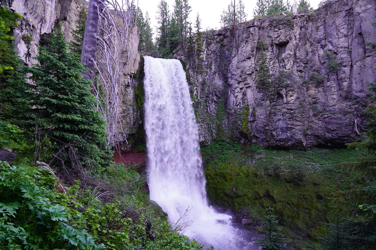
Kicking off our list is the iconic Tumalo Falls, one of the easy hikes in Bend, Oregon. Renowned for its stunning 97-foot waterfall, the Tumalo Falls hike presents various viewpoints to capture that perfect photo of the cascading water against a lush forest backdrop.
The trailhead is located about 20 minutes from downtown Bend, making it an accessible day trip. Upon arriving, you will find ample parking and a facilities area before beginning their ascent towards the falls. One of the things I love about this hike is the viewpoint located just a short walk from the parking area, offering the first of many stunning views of Tumalo Falls without doing a long hike.
For those willing to explore further, the trail continues beyond the falls, winding through dense forests and meadows dotted with wildflowers in the spring and summer months. Along the way, you’ll come across several smaller falls and serene creeks, each presenting their own unique photographic opportunities and moments of peaceful solitude.
The path itself is well-maintained, with clear signage and several benches strategically placed for rest and reflection, making it a rewarding experience for nature lovers of all ages and abilities.
Pilot Butte Hike
Difficulty: Easy
Distance: 1.8 miles – out and back
Elevation: 450 feet
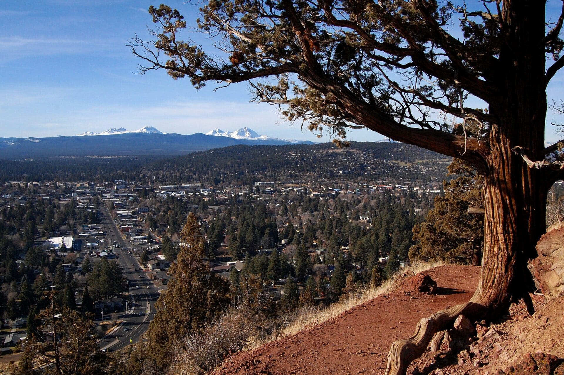
View From Pilot Butte
Pilot Butte presents a unique desert terrain right in the heart of the city. This ancient volcanic cinder cone rises nearly 500 feet above Bend, offering a panoramic vista that includes majestic views of the Cascade Range. The hike to the summit can be approached via several trails, each varying in difficulty, but all leading to the unbeatable 360-degree views at the top.
The trailhead for Pilot Butte is conveniently located within Bend, Oregon, offering easy access for those keen to explore this distinctive landmark. Starting from NE Pilot Butte Drive, adventurers can choose between the nature trail, a more rugged path that wraps around the butte, and the paved road, which is closed to vehicular traffic at certain times, allowing for a leisurely ascent.
Along the trail, hikers are treated to a diversity of desert flora, including fragrant sagebrush, juniper trees, and vibrant wildflowers that add bursts of color in the spring and summer months. Interpretive signs dotting the path provide insights into the area’s geological and cultural history, enhancing the educational aspect of the hike.
The real highlight, however, unfolds as you reaches the summit, where the breathtaking vista spans across the high desert landscape to the snow-capped peaks of the Cascade Mountains, showcasing the natural splendor of Central Oregon.
Misery Ridge Loop Trail
Difficulty: Moderate to Challenging
Length: 6 miles
Elevation: 1,761 feet
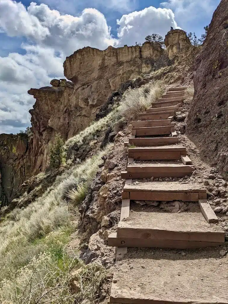
Misery Ridge – Smith Rock State Park
For those who relish a challenge, the Misery Ridge will not disappoint. The trail’s name might hint at difficulty, but the reward is a panoramic view of the surrounding rock formations and the winding Crooked River below. Be prepared for a steep climb, and remember to bring ample water and protection from the sun.
The trailhead for Misery Ridge is found within Smith Rock State Park, near Terrebonne, Oregon, just a short drive north of Bend. Upon entering the park, visitors will readily locate parking and signage directing them towards the path that initiates this adventurous climb. Read my full article about Smith Rock State Park here.
Notable features along the trail include the famous Monkey Face rock formation, a renowned climbing spot that resembles a giant primate’s face, and awe-inspiring views of the Cascade Mountains’ volcanic peaks in the distance. Halfway through the hike, the trail meanders along the top of the ridge, offering expansive vistas of the park and the Crooked River making its way through the ancient canyons.
The descent on the other side completes the loop, bringing adventurers back to the river level, rounding off a truly memorable experience that combines physical exertion with the beauty of Oregon’s high desert landscape.
Steelhead Falls
Difficulty: Easy
Distance: 1.2 miles out and back
Elevation: 226 feet
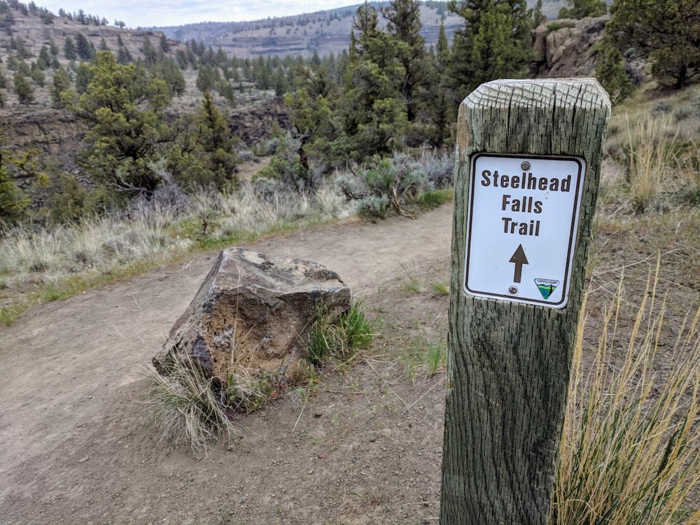
Trail to Steelhead Falls
Steelhead Falls delivers a tranquil setting where hikers can also enjoy the beauty of the Deschutes River. The trail leading to the falls is relatively short, making it an excellent option for a casual day hike. The falls themselves create a serene and picturesque environment, prime for relaxation and picnics.
The trailhead for Steelhead Falls is located within the Deschutes River area, west of Terrebonne, Oregon. To reach it, you will drive down a peaceful country road, which sets the stage for the nature immersion that lies ahead.
Along the way, you might spot local wildlife such as mule deer, golden eagles, and various types of waterfowl. The descent toward Steelhead Falls reveals dramatic views of the Deschutes River Canyon, gradually opening up to the falls themselves. This spot is particularly popular during the warmer months, as the shaded pool beneath the falls offers a cool respite from the heat.
Shevlin Park
Difficulty: Easy to Moderate
Distance: varies, as there are several connecting trails
Elevation: varies, depending on which trail(s) you take
Shevlin Park
Ideal for easy hikes in Bend, Oregon, Shevlin Park is perfect for families or those seeking a less strenuous outdoor experience. With numerous trails winding through the park, hikers can explore meadows, aspen groves, and ponderosa pine forests. This serene park is ideal for wildlife observation and enjoying a leisurely day outdoors.
To reach Shevlin Park, head towards Shevlin Park Road in Bend, Oregon. The park is conveniently located a short drive from downtown, making it easily accessible for all those looking to explore the natural beauty of the area. You will find ample parking, along with facilities like picnic areas and restrooms, providing a comfortable start to your adventure.
As you venture along the trails within Shevlin Park, you’ll be treated to a variety of scenic trails through natural habitats.
The Tumalo Creek Trail, one of the park’s highlights, guides hikers along the creek’s meandering path, offering soothing water sounds and the chance to spot local fish species. The Aspen Trail winds through vibrant aspen groves, especially striking in the fall when leaves turn to gold.
Throughout the park, the diverse flora serves as a habitat for wildlife, including beavers, otters, and a wide range of bird species. Whether looking for a rigorous hike or a peaceful stroll, Shevlin Park’s trails provide a splendid outdoor experience for nature lovers of all ages.
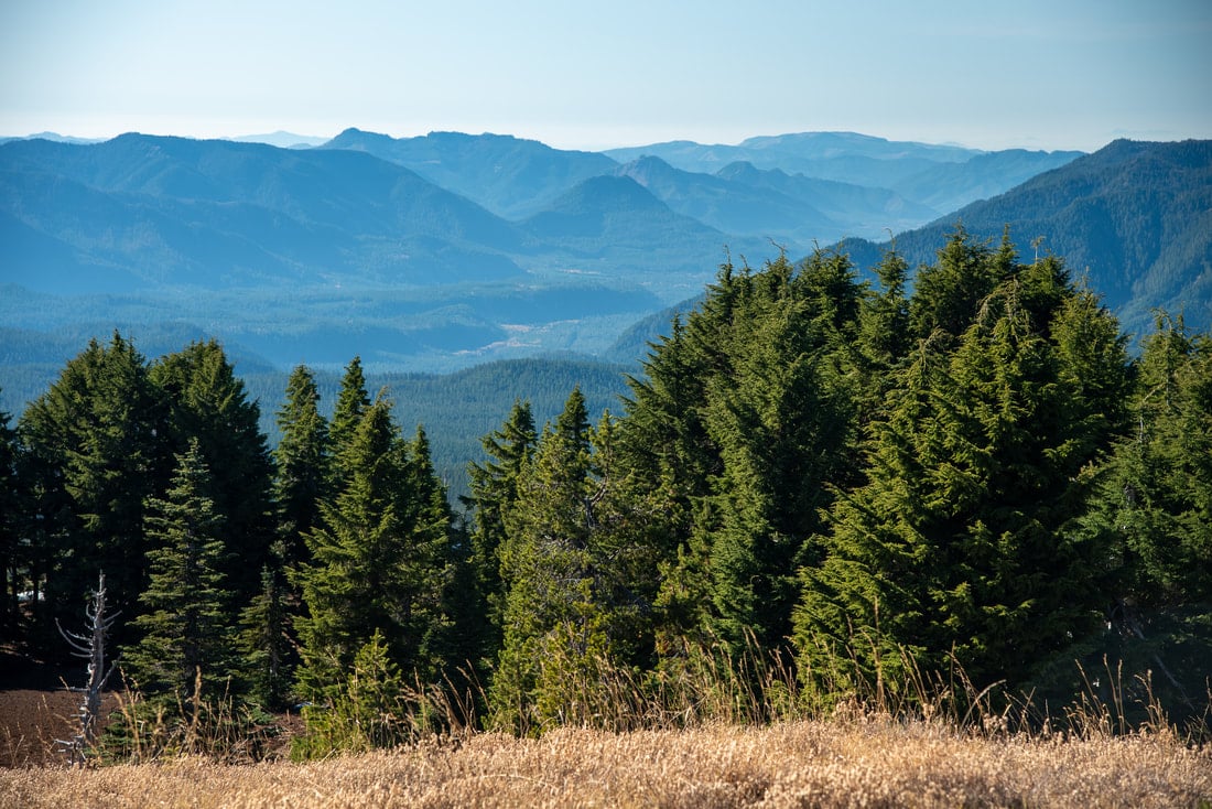
Tumalo Mountain Trail
Difficulty: Moderate
Length: 4 miles
Elevation: 1,440 feet
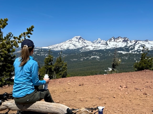
Tumalo Mountain Trail
The Tumalo Mountain Trail is a local favorite for hikers looking to get a view from above. Climbing to the summit, you are treated to sweeping views of the surrounding Cascade Range. Although the trail is rigorous, your efforts are rewarded with a landscape vista that encapsulates the best of Bend’s natural splendor.
The trailhead for Tumalo Mountain Trail is conveniently located off Cascade Lakes National Scenic Byway, just a few miles west of Mt. Bachelor. This starting point is easily identifiable by its well-marked signposts and offers a spacious parking lot, which accommodates the influx of visitors, especially during the warmer months.
I love this trail because it starts you off easy with gradual yet steady ascent, which navigates through a dense forest of pine and fir trees before opening up to the stunning wildflower meadows that dot the landscape in spring and early summer. Soon, the tree line recedes, revealing panoramic views that grow more impressive with elevation.
Near the summit, the terrain becomes rockier, and the path more rugged, challenging adventurers as they near the peak. The true reward comes at the summit, where breathtaking 360-degree views await, showcasing the majestic peaks of the Cascade Range, including Broken Top and the Three Sisters, along with a picturesque overlook of the Central Oregon landscape.
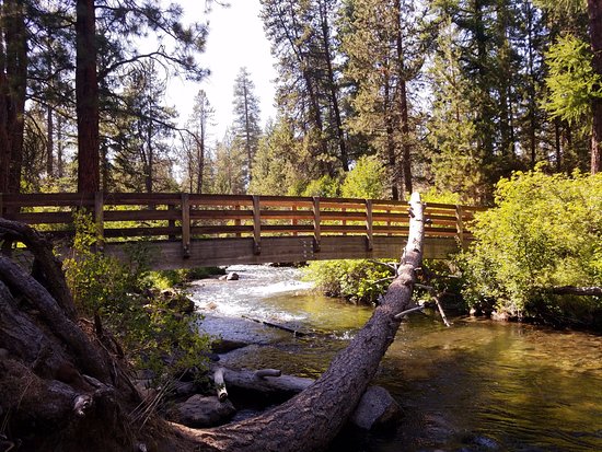
Deschutes River Trail
Difficulty: Easy
Length: varies, depending on how much you want to tackle
Elevation: varies
Deschutes River Trail
Running along the banks of the Deschutes River, this trail is accessible from several parks and is as scenic as it is convenient. The Deschutes River Trail is excellent for those wanting to experience Bend’s natural beauty without venturing too far from the comforts of the city. Hikers can enjoy the sights and sounds of the river, with the opportunity to spot local wildlife along the way.
The primary trailhead for the Deschutes River Trail can be found at Farewell Bend Park, conveniently located near the Old Mill District’s shopping and dining areas. One of the trail’s highlights is the series of footbridges that cross over the crystal-clear waters of the Deschutes River, offering stunning views and opportunities for wildlife observation.
The trail also meanders through lush riparian zones, where the vibrant greenery contrasts beautifully with the desert-like surroundings typical of central Oregon. The trail offers several lookout points where hikers can pause and take in the serene beauty of the river winding its way through the landscape, making it a picturesque retreat.
Lava River Cave
Difficulty: Easy to moderate
Length: 2.2 miles – out and back
Elevation: 250 feet
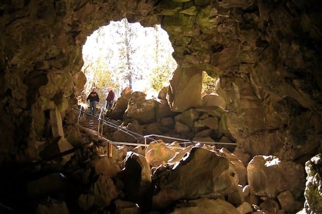
Lava River Cave Courtesy of ShareOregon
Want a twist to your hiking experience? Exploring the underground terrain of the Lava River Cave. This mile-long lava tube offers an adventure unlike any other in the Bend area. Be sure to bring a flashlight and warm clothing, as the cave’s temperature can be quite chilly, even in summer.
The Lava River Cave is nestled within the Newberry National Volcanic Monument, situated roughly 12 miles south of Bend, Oregon. It’s a fascinating geological formation and part of a much larger volcanic landscape that stretches across the region. A visit to the cave is an opportunity to immerse yourself in the stark beauty and silence of an underground world.
Along the path, visitors will encounter smooth and uneven lava formations created by flowing lava thousands of years ago. Also, informational signs dotted along the trail offer insights into the cave’s volcanic origins, the ecosystem within, and the history of exploration in this unique setting. Exploring this unique environment reminded me of the delicate balance of this natural wonder and the importance of preserving its pristine condition.
Scott Mountain Loop Trail
Difficulty: Challenging
Length: 9.1 miles
Elevation: 1,410 feet
Scott Mountain Trail Courtesy of Hike Oregon
This amazing trail is where wildflowers and alpine meadows steal the scene. Hiking through a varied landscape, you’ll get a taste of the region’s diverse ecology and picturesque mountain views.
The Scott Mountain Loop trailhead is conveniently located at the Scott Lake Campground, off McKenzie Highway (OR-242), just a few miles west of Sisters, Oregon. This area serves as both a starting point for the hike and a lovely spot for camping or picnicking before or after your trek.
One of the trail’s most notable features is its stunning vistas of the Three Sisters and Mount Washington, prominent peaks in the Oregon Cascades. The trail meanders through dense forests, opens up to vibrant alpine meadows bursting with wildflowers during the summer months, and offers the chance to spot wildlife native to this region. Important to note that the trail intersects with several others, allowing more adventurous hikers to extend their exploration into the vast wilderness surrounding the Scott Mountain area.

Infographic Courtesy of Rosio Espenoza.
Passes Required for Hiking Around Bend Oregon
In the scenic region surrounding Bend, Oregon, hikers looking to explore the vast network of trails may need to acquire specific passes, ensuring access while contributing to the maintenance and preservation of these natural areas. For trails within the Deschutes National Forest and the Newberry National Volcanic Monument, a Northwest Forest Pass is essential for day use parking.
This pass can be conveniently purchased at several locations, ensuring hikers have easy access before heading to the trails. Those looking to obtain a pass can visit any of the following:
-
- Local Ranger Stations: Here, you can buy passes and receive up-to-date information on trail conditions.
-
- Outdoor Retail Outlets: Many outdoor equipment stores in the region sell the Northwest Forest Pass alongside hiking gear.
-
- Online: For those who prefer to plan ahead, passes can also be purchased online from the official Forest Service website.
This flexibility in purchasing options allows hikers to acquire their pass in the most convenient manner possible, supporting the sustainability of these cherished natural areas.
Additionally, the Central Cascades Wilderness Permit is required for both day use and overnight access to certain wilderness areas during peak season (late spring through early fall), aiming to reduce environmental impact and improve the visitor experience.
**It’s advisable for hikers to plan ahead and secure these passes well in advance, especially during the high season, to ensure a smooth and enjoyable outdoor adventure in Bend’s breathtaking landscapes.
Central Cascades Wilderness Permits can be obtained through a reservation system managed by Recreation.gov. This platform allows visitors to reserve day-use permits and overnight permits for specific entry dates and trails within the Central Cascades Wilderness areas.
Reservations typically open in the spring, and it’s highly recommended to book as early as possible due to high demand, especially for popular trails and weekend dates. Limited quantities of permits may also be available on a first-come, first-served basis each day, but securing a permit in advance is the best way to ensure access to these protected areas.
FAQs
Is Bend Oregon good for hiking?
The Bend area has some of the best hiking in the entire state of Oregon. Whether you want to stay in town or ventures further out around the Mt. Bachelor or Sisters area, there is a trail that will satisfy any hiker, beginner or experienced.
How long of a hike is Tumalo Falls?
Depending on how long you want to hike, the trail can be anywhere from ½ miles to the full 6.8 mile loop trails.