Oregon is known for its waterfalls, but did you know you can see at least 10 of them along one spectacular drive? Having lived in Portland for over 20 years, this road of waterfalls was on my radar for quite some time.
If you’ve ever dreamed of a road trip filled with thundering waterfalls, moss-covered forests, and scenic highway views — this is the route for you. Oregon’s “Highway of Waterfalls,” highway 138 is one of the most underrated drives in the Pacific Northwest, with over a dozen stunning cascades packed into just a few hours of road time.
If you are staying in Eugene or Roseburg, this road trip makes for a good day trip of waterfall hikes nearby. So, if you find yourself in southern Oregon for any reason, do make it a point to drive this historic and very scenic highway!
**This post contains affiliate links. When you click through and book any of the properties below, I receive a small commission at no extra cost to you. Thanks for supporting Explorer Sue!**
Easy Hikes in Oregon with Waterfalls Along Hwy 138
I finally drove this route last summer and was blown away by how accessible and awe-inspiring each stop was — from short strolls to dramatic viewpoints to longer hikes deep into the forest. Whether you’re a nature lover, photographer, or just want a peaceful detour off I-5, this road trip delivers.
In this guide, I’ll show you exactly how to plan the perfect Oregon waterfall road trip, including my personal tips for each stop, drive times, and the best season to go. Let’s hit the road — and the mist! These waterfall hikes near Portland make for a great road trip!
The epic road trip takes 2-3 days to fully explore, but you can do it in a day if you choose to stop at just 4-5 waterfalls. You can start either from the west side in Roseburg, or east if you’re coming from the Crater Lake area.
We’ll be starting this waterfall road trip from Roseburg. If you’ve forgotten snacks or a picnic lunch, you can load up on food in the tiny town of Glide at the only gas station in town as you head east on Highway 138.
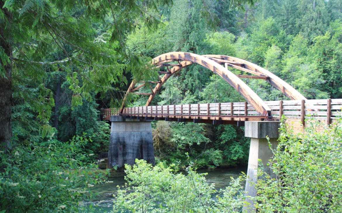
In Glide, the North Umpqua River and Little River collide in a fury of white water – one of the few places in the world where two rivers meet head on! From here, the byway parallels the North Umpqua River. White water rafting and kayaking are popular sports along the river, as well as fly-fishing.
The North Umpqua Trail – The Ultimate Waterfall Trail
This is a whopping 79-mile trail that follows the North Umpqua River from Swiftwater Park, where it meets up with the Pacific Crest Trail. With twelve trailheads, there are plenty of opportunities to enter the trail, with a variety of experiences for different ability levels. Old-growth Douglas Fir, Mountain Hemlock, and many other indigenous species of trees make their home here. Much of this hiker-only trail (not open to horses) is best experienced for short segments at a time.
It’s also the trail where most of the waterfalls I mention in this post can be found on foot.
The North Umpqua River is a popular spot for fishing large summer-run steelhead, and many fly-fishing enthusiasts can be found along its banks. Between May and October, migrating salmon and steelhead can be seen jumping at Deadline Falls.
Want a map of the trails and accommodation options?? Here you go.
Susan Creek Falls
It’s always fun to visit a falls that has the same name as you. Somehow you just expect more. For me, Susan Falls delivered. As you approach from the highway a little past milepost 28, there is a great picnic area and a trail along the river if you pull off on the right side of the road, and signs will guide you to parking. But the falls are actually on the left side of the road, with its own little parking space. It’s easy to miss, as there are no signs for Susan Falls from the highway, just signs for Susan Creek. Once you park, it is a nice easy ¾ mile hike to Susan Falls.
Pro Tip: There is one picnic table right next to the falls, so bring snacks! Be sure to wear waterproof shoes—the trail can get slick near the base.
The mossy rock walls around Susan Creek Falls felt like a cathedral; pausing at the viewpoint made me truly slow down and breathe in the green calm.
The trails will also take you to the Susan Creek mounds, where young Native American boys approaching manhood would fast and build stone piles, then spend the night in search of visions from guardian spirits. Once you pass the falls to the mounds, the trail gets more difficult.
Fall Creek Falls
A bit past milepost 32, park on the left side of the highway for Fall Creek. It is a tiered-type waterfall that flows over a 35-foot drop, then a 50-foot drop to a pool below. The trail here is a bit more challenging, leading you through a bedrock crevice of basalt and lush vegetation.
I dipped my toes in the pool below Fall Creek Falls in the hot afternoon—the chill was instantly refreshing, worth that few-minute walk in.
Pro Tip: Bring a swimsuit—this tiered waterfall creates a beautiful swim-ready pool, ideal for a summer dip.
Steamboat Falls
This one is not quite as spectacular, but very pretty nonetheless. This waterway is an important steelhead-spawning tributary and is a 25-foot block-type fall, and steelhead can be seen jumping to the top of the fall during the late Spring through early fall months.
During my visit, I happened upon steelhead navigating a ladder next to the cascade—an unexpected glimpse into local wildlife in motion.
When you reach milepost 38.8, turn onto Steamboat Road 38, and go another 5.3 miles until you reach Road 3810. Turn right, then go another ½ mile until you see signs for Steamboat Fall campground. From here, it is an easy hike to this waterfall.
Pro Tip: Try to time your visit between May and July to catch salmon and steelhead attempts at the falls adjacent to the fish ladder.
Want more waterfalls? Here are the 20 Best Waterfall Hikes in Oregon.
Toketee Falls
The Toketee Falls is double-tiered and drops a dramatic 120 feet through pristine rows of columnar basalt into a gorgeous blue basin. Park at milepost 59, then turn north on Forest Road 34 and follow the signs for parking. While the hike to the falls is less than a half-mile, it is somewhat challenging, with a rocky trail and over 200 steps to the viewing platform.
Walking the short trail to Toketee Falls felt like entering a fairy tale—the basalt amphitheater framed the two-stage cascade perfectly, gravity in motion.
These falls were formed over 30,000 years ago when a series of fluid lava flows, originating from Mt. Bailey, funneled down the North Umpqua River Canyon. After slowly cooling, the lava contracted into slender prism-shaped columns. The river carved a notch through these columns, first at 40 feet and then 80 feet into a roomy plunge pool.
Pro Tip: Plan for fall colors—October and November bring fiery foliage that frames the falls beautifully.
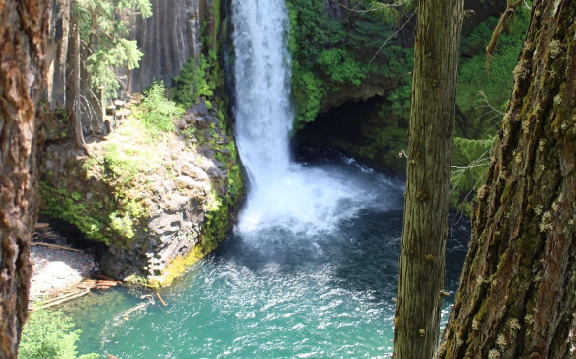
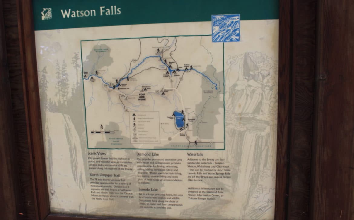
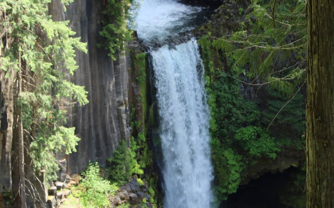
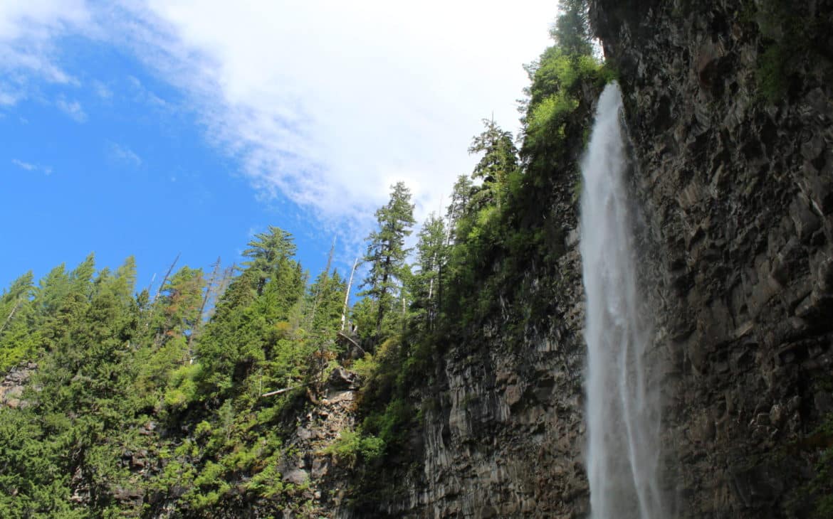
Watson Falls
At 293 feet, Watson Falls is the highest waterfall in Oregon’s southwest region. Visit the picnic area for interpretive exhibits and a partial view of Watson Falls, right from the parking area off of milepost 61.3 (turn south to Forest Road 37 from Highway 138.)
Seeing Watson Falls made me pause at the bridge lookout; its full 272-foot drop felt awe-inspiring from every angle. It’s quite something to hear the hollow thump of the old-growth forest floor beneath your feet. This trail can be easy or difficult, depending on how far you want to go.
You can still view the falls from down below while resting on a park bench. But if you want to go full throttle, take the sharp ascent up through a couple of switchbacks to get a close-up view of the falls, and feel the slight spray of water on your face. Refreshing!
Pro Tip: The falls are visible from the parking area, but the .4-mile moderate hike with a bridge viewpoint gives far better perspective—worth the extra effort.
Whitehorse Falls
This short-ish waterfall tumbles 15 feet into a punchbowl and provides a relaxing setting for a picnic. Convenient to the parking area just off of milepost 66, there is also an accessible viewing platform. While this waterfall is not as spectacular as the others, it offers a relaxing respite from all of your hiking thus far.
Clearwater Falls
At milepost 69, it is a short walk to enjoy another relaxing waterfall, with crystal clear, cold waters cascading over the green rocks. There is also a day-use area here, with an accessible trail, viewing platform, and picnic area.
Warm Springs
For this one, you get to do an easy hike that leads to the top of the fall, with a drop of more than 70 feet. There is no access to the bottom of the falls. Find it by turning off Highway 138 at milepost 72.8 to Road 2610, then go about six miles, and turn left on Road 600. Then go about 3 miles to Road 680. Turn left and drive another 1.7 miles to the trailhead #1499.
Lemolo Falls
Lemolo in the ancient Chinook language means “wild” or “untamed” and when you first lay eyes on these falls, you will see why. It’s a gorgeous Horsetail falling dramatically off a stony cliff. But (isn’t there always a ‘but’?) the 1.7-mile trail to get here is not of the easy variety. Still, if you are reasonably healthy, you’ll make it.
Need Help Planning? Get a Custom Pacific Northwest Itinerary
You can find Lemolo Falls by turning onto Road 2610 from milepost 72.8, then it’s a little over five miles to Lemolo Lodge. Cross over a dam, then bear left at the fork in the road. In another half mile, turn left across the wooden bridge and you will find parking at the trailhead.
Clearwater Falls at Diamond Lake
This is the last stop on our journey before the road heads south toward Crater Lake. Diamond Lake is a stunning alpine lake and a resort unto itself, with amazing views of Mt. Theilson and Mt. Bailey. There is camping, trail hiking, and a great view of Clearwater Falls (mentioned above). Its cold, clear waters cascade down over moss-covered rocks.
You can’t get more Oregon than that.
Where to Stay along Highway 138
Susan Creek Campground. This is one of the best campgrounds in the area, located just a few miles east of Roseburg.
Steamboat Inn. This is a great resort in the forest with modern cabins, suites, and cottages. There is also a great restaurant on site. Great for groups to share accommodations and perfect for adventurous and romantic couples.
Diamond Lake Resort. Fishing, hiking, cycling, horseback riding…you can find it all here. The resort offers cabins, motel-like rooms, and even one lonely jacuzzi suite! Better book that one early!
Where to Stay in Eugene, Oregon
Eugene is a convenient place to stay if you want to combine the waterfall route with restaurants, breweries, shopping, or other attractions in the southern Willamette Valley. Keep in mind that Eugene is about 70 miles north of Roseburg, so it works best as a base before or after your Highway 138 road trip rather than for exploring the entire route in one day.
Holiday Inn Express & Suites Eugene Downtown–University
Located near the University of Oregon, this reliable mid-range hotel offers spacious rooms, free parking, complimentary breakfast, and an indoor pool. Its location near Franklin Boulevard also provides easy access to Interstate 5, making it a practical choice for travelers continuing south toward Roseburg and Highway 138.
Timbers Inn is an affordable, locally styled motel in downtown Eugene. The property has a fun retro-modern feel and places you within walking distance of downtown restaurants, breweries, and entertainment. Free parking and breakfast add value, making this a good option for travelers who want something with more personality than a standard chain hotel.
Where to Stay in Roseburg, Oregon
Roseburg is the most convenient city for beginning the Highway 138 waterfall drive from the west. Staying here allows you to stock up on food, fill the gas tank, and get an early start before heading into the North Umpqua River corridor.
This comfortable mid-range hotel sits just off Interstate 5 and makes an easy overnight stop before your waterfall road trip. Guests receive free hot breakfast, parking, and Wi-Fi, while the indoor saltwater pool and fitness center are welcome extras after a long day of driving or hiking. It is a particularly good choice for families or travelers who prefer the predictability of a newer chain hotel.
For a more scenic and budget-friendly stay, Riverfront Inn sits beside the South Umpqua River near downtown Roseburg. Some rooms offer river views, and the property includes a garden, seasonal outdoor pool, firepit, free parking, and a light continental breakfast. Choose this one if you would rather relax beside the river than stay in a typical roadside hotel.