21 Epic Hikes in Olympic National Park for Every Adventure Level
Best Hiking in Olympic National Park
Planning a trip to Olympic National Park and wondering which trails are actually worth your time? With over 600 miles of trails, this wild and varied park can be both a dream and a logistical nightmare for hikers. I’ve been there — trying to figure out which hikes offer waterfalls, which are family-friendly, and which lead to those unforgettable alpine views.
That’s why I created this guide: to help you skip the overwhelm and find the best Olympic National Park hikes based on your adventure level. Whether you’re looking for rainforest strolls, coastal tide pools, or calf-burning climbs, these 21 hikes offer something incredible — and I’ve included trail stats and planning tips for each to make your trip smoother.
Let’s find your perfect trail.
Beginner & Moderate Adventure Hikes
Accessible options with great views.
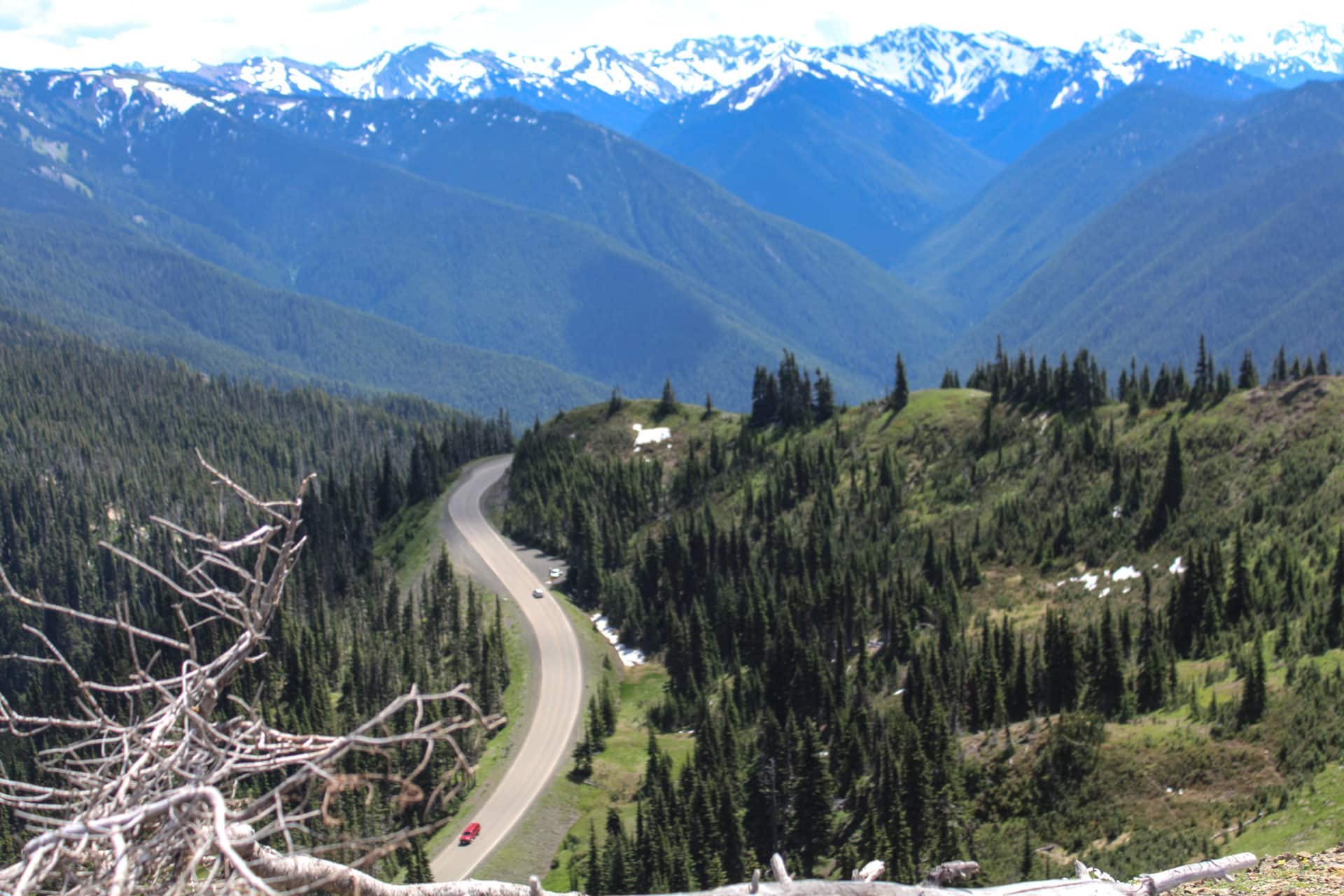
Hurricane Hill Trail
- Trailhead: Hurricane Ridge Parking Lot
- Distance: 3.2 miles round trip
- Difficulty: Easy to Moderate
- Elevation Gain: ~650 feet
- Type: Out-and-back
Paved and popular, this alpine trail features panoramic views of the Olympic Mountains, Puget Sound, and even Canada on a clear day. You can often see Olympic marmots sunning on the rocks right beside the paved trail.
Ozette Triangle (Cape Alava Loop)
- Trailhead: Ozette Ranger Station
- Distance: 9.4 miles
- Difficulty: Moderate
- Elevation Gain: ~300 feet
- Type: Loop
This coastal hike combines forest boardwalks with rugged beach walking. Don’t underestimate the boardwalk’s slickness — I almost wiped out on a mossy step! Sea stacks, tide pools, and petroglyphs make this a favorite among backpackers.
Sand Point Trail
- Trailhead: Ozette Ranger Station
- Distance: 6.2 miles round trip
- Difficulty: Moderate
- Elevation Gain: ~200 feet
- Type: Out-and-back
Bring binoculars — we spotted sea otters bobbing just offshore during a snack break. Boardwalks lead to a peaceful beach with tide pools and distant sea stacks. This trail is a quieter alternative to the full Ozette Triangle.
Cape Alava Trail
- Trailhead: Ozette Ranger Station
- Distance: 6.2 miles round trip
- Difficulty: Moderate
- Elevation Gain: ~200 feet
- Type: Out-and-back
A mirror hike to the Sand Point Trail, this one leads to a historic Makah site and spectacular views of the Pacific. Watch for petroglyphs at Wedding Rocks — they’re easy to miss but incredible to see up close.
Goblins Gate Trail
- Trailhead: Whiskey Bend Trailhead (Elwha Valley)
- Distance: 1.2 miles round trip
- Difficulty: Moderate
- Elevation Gain: ~200 feet
- Type: Out-and-back
This short trail brings you to a dramatic gorge where the Elwha River squeezes between cliffs. A wooden bridge offers stunning views, and the gorge is surprisingly dramatic — I gasped when I saw the narrow slot the river carves through.
Elwha River Trail to Humes Ranch
- Trailhead: Whiskey Bend Trailhead (Elwha Valley)
- Distance: 5 miles round trip
- Difficulty: Moderate
- Elevation Gain: ~600 feet
- Type: Out-and-back
Walk through old homesteads, meadows, and mossy forests on this peaceful hike along the Elwha River. The old homestead clearing makes a peaceful picnic spot — and a break for tired feet.
Rialto Beach to Hole-in-the-Wall
- Trailhead: Rialto Beach Parking Area
- Distance: 3.4 miles round trip
- Difficulty: Moderate
- Elevation Gain: Negligible
- Type: Out-and-back (beach walk)
Explore the sea arch and tide pools at Hole-in-the-Wall. Time this hike with low tide — it’s the only safe way to reach the sea arch and tide pools. Sea stacks and driftwood add to the drama.
Third Beach to Strawberry Point
- Trailhead: Third Beach Trailhead (La Push area)
- Distance: 6.4 miles round trip
- Difficulty: Moderate
- Elevation Gain: ~250 feet
- Type: Out-and-back
A classic coastal hike with beachcombing, cliffs, and tide pool exploration. A muddy trail led us to one of the most peaceful beach campsites I’ve ever found.
Waterfall Hikes
For those chasing misty cascades and dramatic falls.
Sol Duc Falls Trail
- Trailhead: End of Sol Duc Road
- Distance: 1.6 miles round trip
- Difficulty: Easy
- Elevation Gain: ~200 feet
- Type: Out-and-back
This easy trail takes you through an old-growth forest to one of the park’s most famous waterfalls. Expect crowds in summer, but the thunderous, multi-streamed falls are absolutely worth it. Sol Duc Falls spills dramatically into a narrow canyon, and a bridge crossing offers the perfect photo op.
Marymere Falls Trail
- Trailhead: Storm King Ranger Station (Lake Crescent)
- Distance: 1.8 miles round trip
- Difficulty: Easy
- Elevation Gain: ~300 feet
- Type: Out-and-back
This family-friendly trail offers forested beauty and a lovely waterfall at the end. The last short, steep climb can be slippery — sturdy shoes (and patience with kids) are a must. The final ascent includes a short but steep climb to the viewing platform.
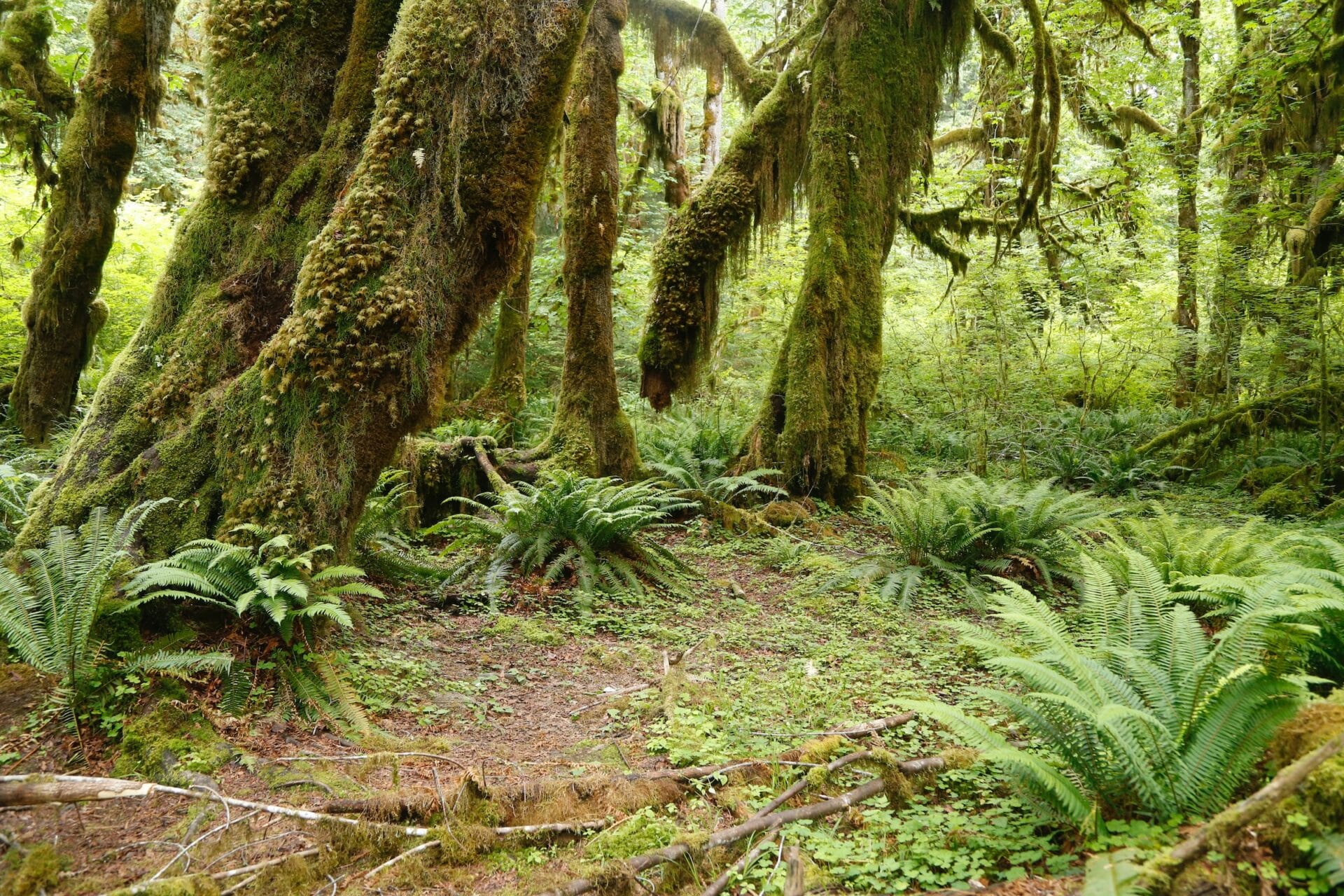
Hoh River Trail to Five Mile Island
- Trailhead: Hoh Rain Forest Visitor Center
- Distance: 10 miles round trip
- Difficulty: Moderate
- Elevation Gain: ~300 feet
- Type: Out-and-back
Expect a tranquil, lush rainforest experience as you follow the Hoh River through groves of Sitka spruce, ferns, and mossy maples. I spotted a herd of elk grazing quietly along the riverbank just past the halfway point. The wide, well-maintained trail is perfect for immersing yourself in the heart of the park’s rainforest ecosystem. Five Mile Island makes a lovely turnaround point with river views and elk sightings.
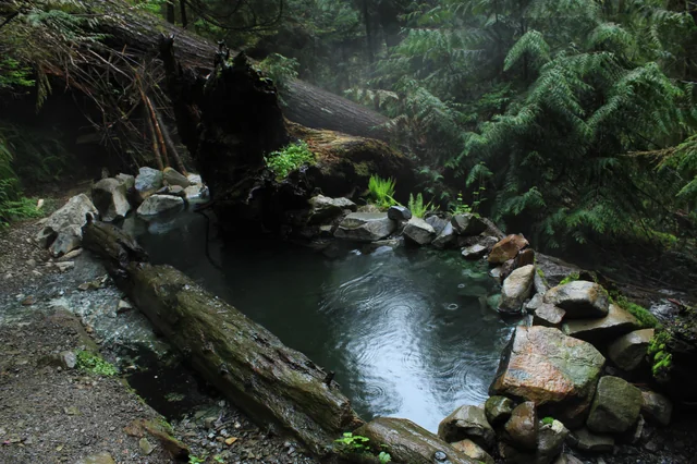
Lover’s Lane Loop
- Trailhead: Sol Duc Hot Springs Resort
- Distance: 6 miles
- Difficulty: Moderate
- Elevation Gain: ~600 feet
- Type: Loop
We timed this for early evening and caught golden light filtering through the old-growth trees near the river. The trail combines forest paths, river crossings, and waterfall views. It’s a great way to connect Sol Duc Falls with Sol Duc Hot Springs for a post-hike soak.
Family-Friendly Hikes
Short, scenic, and great for all ages.
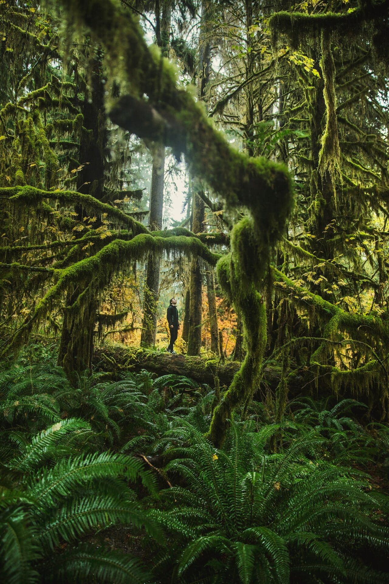
Hall of Mosses Trail
- Trailhead: Hoh Rain Forest Visitor Center
- Distance: 0.8 miles
- Difficulty: Easy
- Elevation Gain: ~100 feet
- Type: Loop
Kids always get wide-eyed here — the moss-draped trees look like something out of a fantasy movie. Short but magical, this loop winds through a forest of towering trees draped in thick, green moss. Interpretive signs explain the unique ecology of the temperate rainforest, making this a great hike for families and nature lovers.
Second Beach Trail
- Trailhead: Second Beach Trailhead (La Push area)
- Distance: 1.4 miles round trip
- Difficulty: Easy
- Elevation Gain: ~150 feet
- Type: Out-and-back
This short trail offers quick access to one of the most photogenic beaches in the park. We brought dinner and caught one of the most unreal sunsets I’ve seen in Washington. Sea stacks rise from the waves, and sunsets are legendary.
Big Spruce Tree Trail
- Trailhead: Near Quinault Rain Forest Ranger Station
- Distance: 0.3 miles round trip
- Difficulty: Easy
- Elevation Gain: ~30 feet
- Type: Out-and-back
Visit one of the largest Sitka spruces in the world. This massive Sitka spruce is so wide I couldn’t reach halfway around the trunk — a humbling sight. This easy walk is perfect for families and those short on time.
Staircase Rapids Loop
- Trailhead: Staircase Ranger Station (SE corner of park)
- Distance: 2.1 miles
- Difficulty: Easy to Moderate
- Elevation Gain: ~200 feet
- Type: Loop
A mellow forest hike along the North Fork Skokomish River. This is my go-to when I want a quiet morning hike with forest, river, and just enough movement. The loop crosses a scenic suspension bridge and is a favorite for birdwatching and forest bathing.
Expert Hiker Trails
Strenuous hikes with big payoffs.
Mount Storm King
- Trailhead: Storm King Ranger Station (Lake Crescent)
- Distance: 4 miles round trip
- Difficulty: Hard
- Elevation Gain: ~2,100 feet
- Type: Out-and-back
This steep, challenging hike is rewarded with jaw-dropping views of Lake Crescent and a rope-assisted scramble near the summit. I turned back my first time at the ropes because I was woefully unequipped — bring gloves and confidence if you want to summit.
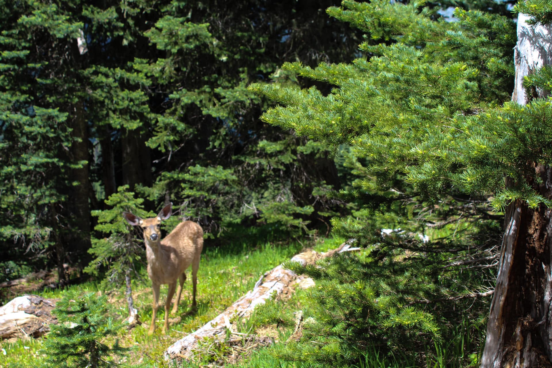
Pyramid Peak Trail
- Trailhead: Near North Shore of Lake Crescent (North Shore Picnic Area)
- Distance: 6.2 miles round trip
- Difficulty: Hard
- Elevation Gain: ~2,400 feet
- Type: Out-and-back
This less-traveled trail climbs to stunning lake views and passes through a quiet forest with occasional glimpses of wildlife and wildflowers. I saw zero people and three deer on this trail — a gem if you’re craving solitude and a challenge.

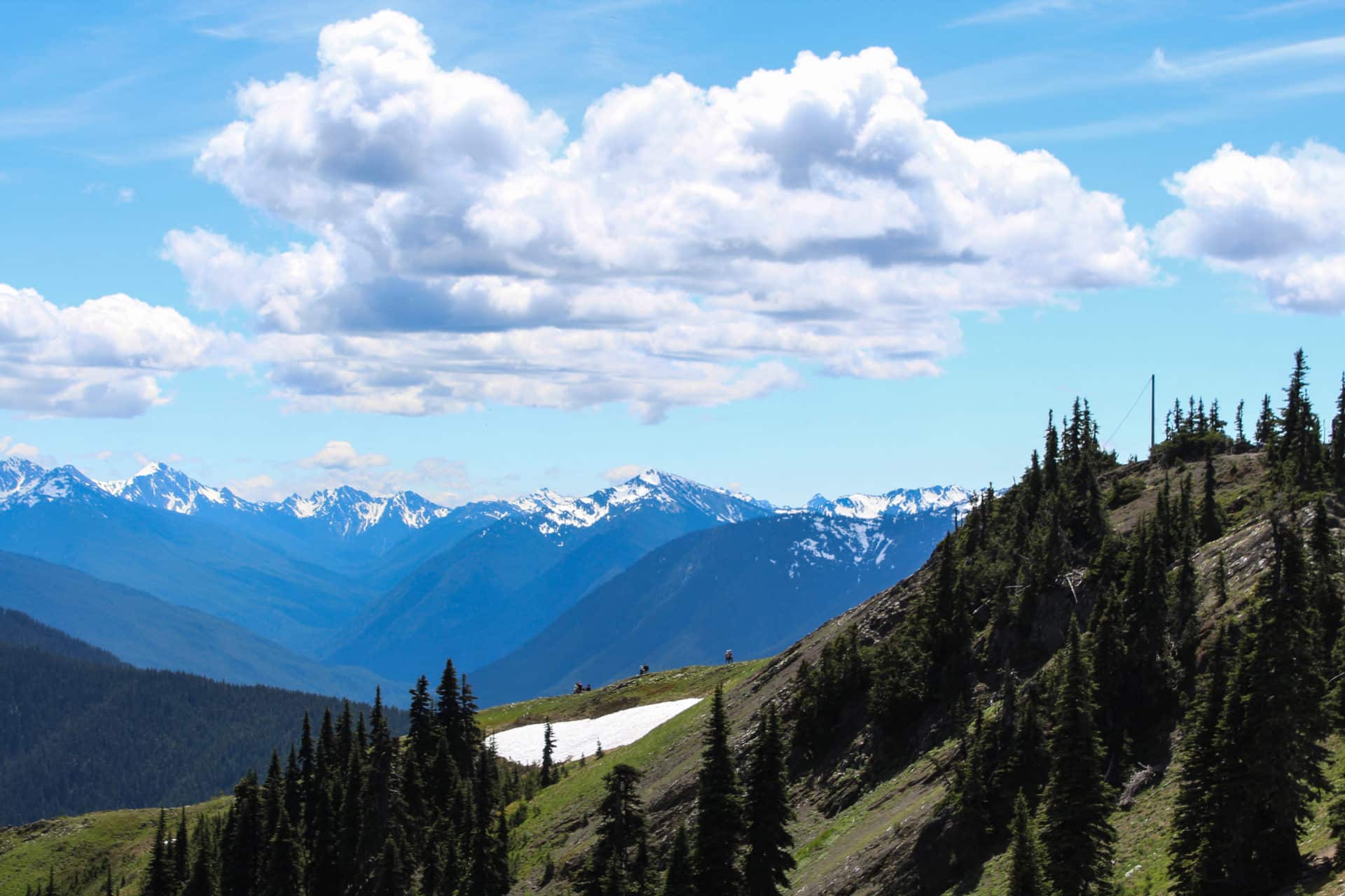
Switchback Trail to Klahhane Ridge
- Trailhead: Switchback Trailhead (on Hurricane Ridge Road)
- Distance: 3.3 miles round trip
- Difficulty: Hard (steep)
- Elevation Gain: ~1,500 feet
- Type: Out-and-back
A steep incline to Klahhane Ridge is brutal, but the view over the ridge feels like stepping into another world. Wildflowers dot the slopes in summer.
Mount Angeles via Heather Park Trail
- Trailhead: Heather Park Trailhead (near Hurricane Ridge Road)
- Distance: 8.2 miles round trip
- Difficulty: Moderate
- Elevation Gain: ~3,400 feet
- Type: Out-and-back
This strenuous climb rewards you with panoramic views of the Olympics, Puget Sound, and beyond. I made it halfway up before clouds rolled in, reminding me just how fast mountain weather changes. Expect wildflowers, alpine meadows, and a thrilling summit.
Enchanted Valley Trail
- Trailhead: Graves Creek Trailhead (Quinault area)
- Distance: 13 miles one way (backpackers often overnight)
- Difficulty: Moderate to Hard
- Elevation Gain: ~1,300 feet
- Type: Out-and-back
Nicknamed the “Valley of 10,000 Waterfalls,” this trail follows the East Fork Quinault River past giant trees and into a remote alpine valley. At one point we spotted black bears across the river and a chorus of waterfalls echoing through the valley.
Planning Tips for Hiking in Olympic National Park
Before you lace up your boots, here are a few key things to know for a safe and epic hiking adventure in Olympic:
- Best Time to Visit:
Late June through early October offers the best trail conditions, especially for alpine hikes. Coastal and rainforest trails are accessible year-round, but winter brings heavy rain and occasional snow. - Weather Varies by Region:
Olympic has multiple ecosystems, so be prepared for anything. Rainforests like Hoh are damp even in summer, while Hurricane Ridge can get snow well into spring. Always check the weather for the specific region you’re visiting. - Trail Conditions and Closures:
Some backcountry and coastal hikes may require permits or have seasonal closures due to washouts or wildlife. Check trail updates on the National Park Service website before you go. - What to Pack:
Sturdy hiking shoes, layers (including rain gear), bug spray, and sun protection are essentials. For higher-elevation or rope-assisted hikes like Mount Storm King, gloves and traction may help. - Tide Timing for Beach Hikes:
If you’re hiking to Hole-in-the-Wall or Cape Alava, check the tide schedule. Some sections are only passable at low tide and can be dangerous otherwise.
Map of Olympic National Park Hikes
